
Norway is one of Europe’s most dramatic hiking destinations, known for its towering fjords, rugged mountain ridges, and vast untouched wilderness.
From iconic cliffside viewpoints like Trolltunga to scenic ridge walks in Jotunheimen National Park, the country offers a mix of challenging treks and accessible day hikes.
In this guide, you’ll find the best hikes in Norway, each broken down with practical details to help you choose the right trail for your trip.
Quick Picks: Best Hikes in Norway
If you’re short on time or just want the highlights, these are the hikes that stand out:
- Best iconic hike – Trolltunga Trek
- Best cliffside viewpoint – Preikestolen (Pulpit Rock)
- Best ridge hike – Besseggen Ridge
- Best dramatic photo spot – Kjeragbolten
- Best short but steep climb – Reinebringen Ridge
- Best scenic ridge traverse – Romsdalseggen Ridge
Why Hike in Norway
Norway is every hiker’s dream come true, and it boasts of some of the most jaw-dropping landscapes in Europe.
Just imagine trekking through towering fjords, exploring majestic glaciers, or wandering along serene lakes that are nestled beneath rugged mountain peaks.
Or picture yourself standing on the famous Trolltunga, overlooking stunning fjords and valleys, and then navigating the wilderness of Jotunheimen National Park, which is home to Norway’s tallest peaks.
That’s exactly what you can expect in Norway.
Companion Article: Ultimate Guide to Hiking in Norway
Planning a full hiking trip? Our complete guide covers hiking regions, weather, trail types, and practical travel tips.
Read the full guide: Hiking in Norway: The Ultimate Guide
“Every hiker starts somewhere — grab your free Hiking for Beginners guide.”
The Best Hikes in Norway
In this guide, we’ll dive into the six very best hikes that you will get to experience in Norway.
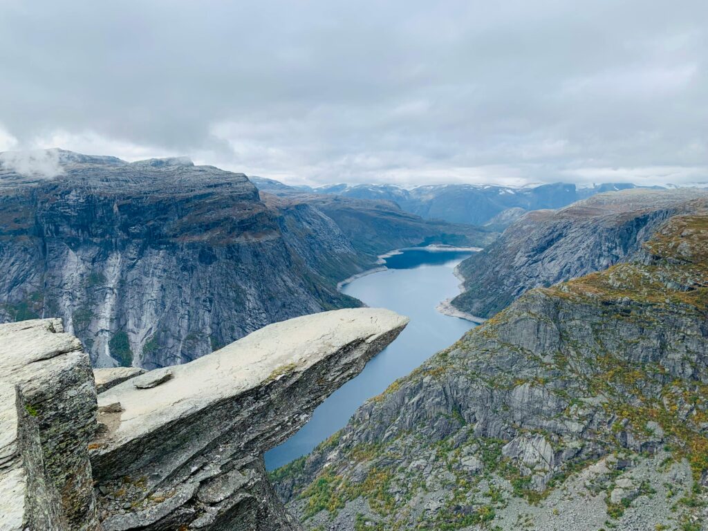
1. Trolltunga Trek
Trolltunga, which means “Troll’s Tongue,” is easily one of Norway’s most renowned and breathtaking hiking destinations.
his iconic trail takes you to a dramatic rock formation that extends horizontally from the mountain, and it offers unparalleled views of the surrounding fjords and mountains.
Trail Snapshot
Difficulty: Challenging
Distance: 28 km round trip
Elevation Gain: ~900 m
Start / End: Skjeggedal → Trolltunga → return
Highlights: iconic rock formation, fjord views, dramatic cliffs
Difficulty/Recommended Fitness Level
The Trolltunga Trek is considered to be strenuous, which makes it ideal for hikers with a good level of fitness and some prior hiking experience. The trail involves steep ascents and descents, rocky paths, and long distances.
Distance
Covering approximately 28 kilometers (17 miles) round trip, the Trolltunga Trek is a substantial hike that typically takes between 10 to 12 hours to complete.
Elevation Gain
The trek features a significant elevation gain of around 900 meters (2,952 feet), which presents a challenging climb that tests both physical and mental endurance.
Start and End Point
The hike begins at Skjeggedal, which is a small mountain lodge that serves as the trailhead for Trolltunga. Located about 23 kilometers (14 miles) from the town of Odda, Skjeggedal is accessible by car or shuttle services from nearby towns.
From the lodge, you will follow well-marked paths that will guide you until you eventually reach the iconic Trolltunga.
Get to the Trailhead
Accessible by car or shuttle from Odda. Parking is limited, so arrive early.
Highlights & Landmarks
Trolltunga is one of Norway’s most iconic viewpoints. The panoramic fjord views are unforgettable.
2. Preikestolen (Pulpit Rock) Hike
Preikestolen, or “Pulpit Rock,” is one of Norway’s most famous and awe-inspiring hiking destinations.
This iconic trail leads you to a massive cliff that rises 604 meters (1,982 feet) above the Lysefjord, which offers panoramic views that are simply breathtaking.
Trail Snapshot
Difficulty: Moderate
Distance: 8 km round trip
Elevation Gain: ~350 m
Start / End: Preikestolen Mountain Lodge
Highlights: cliff viewpoint, Lysefjord views
Difficulty/Recommended Fitness Level
The Preikestolen hike is considered moderate, which makes it suitable for hikers with a reasonable level of fitness and some hiking experience. The trail is well-marked and primarily consists of a gradual ascent with a few steep sections.
Distance
Covering approximately 8 kilometers (5 miles) round trip, the Preikestolen hike is a manageable distance that can typically be completed in around 4 to 5 hours.
Elevation Gain
The hike features an elevation gain of about 350 meters (1,148 feet), which presents a steady climb.
Start and End Point
The hike begins at the Preikestolen Mountain Lodge, which is located near the town of Forsand.
From the lodge, you will follow the well-marked paths that guide you through lush forests and open meadows, and it eventually leads to the iconic Pulpit Rock.
Get to the Trailhead
Accessible by car from Stavanger. Parking and facilities are available.
Highlights & Landmarks
The cliff rises 604 meters above Lysefjord. It’s one of Norway’s most photographed spots.
3. Romsdalseggen Ridge Hike
Located in the heart of the Romsdal Valley, this trail offers hikers like you a chance to traverse dramatic mountain landscape and lush valleys.
The Romsdalseggen Ridge Hike is perfect for those of you who are seeking a memorable adventure with some of the most breathtaking scenery Norway has to offer.
Trail Snapshot
Difficulty: Challenging
Distance: 10 km
Elevation Gain: ~600 m
Start / End: Åndalsnes → ridge route
Highlights: ridge walking, Troll Wall views
Difficulty/Recommended Fitness Level
Overall, the Romsdalseggen Ridge Hike is ideal for hikers with a good level of fitness and some hiking experience. The trail includes steep ascents, narrow ridges, and rocky paths.
Distance
Covering approximately 10 kilometers (6.2 miles) round trip, the Romsdalseggen Ridge Hike is a substantial trek that typically takes around 6 to 8 hours to complete.
Elevation Gain
The hike features an elevation gain of about 600 meters (1,969 feet), which presents a steady climb that challenges both physical strength and endurance. But there are also ample opportunities to rest and soak in the surrounding natural beauty.
Start and End Point
The hike begins at the Romsdalseggen Trailhead, which is located near the town of Åndalsnes. Accessible by car or public transport.
From the trailhead, you will follow well-marked paths that lead you through picturesque valleys and up to the ridge, where the true beauty of Romsdalseggen unfolds.
Get to the Trailhead
Accessible by train or car to Åndalsnes. Shuttle options may be available.
Highlights & Landmarks
Views of Trollveggen (Europe’s tallest vertical rock face) are a major highlight.
4. Besseggen Ridge Hike
Besseggen Ridge is located in the heart of Jotunheimen National Park.
This trail takes you along a narrow ridge that offers breathtaking views of the turquoise Gjende Lake on one side and the deep blue Bessvatnet Lake on the other.
The Besseggen Ridge Hike is perfect for those of you seeking an unforgettable adventure amidst some of Norway’s most dramatic landscapes.
Trail Snapshot
Difficulty: Moderate–Challenging
Distance: 14 km
Elevation Gain: ~600 m
Start / End: Gjendesheim → Memurubu
Highlights: twin lakes, ridge walk
Difficulty/Recommended Fitness Level
Overall, the Besseggen Ridge Hike is ideal for hikers with a good level of fitness and some hiking experience. The trail includes steep ascents, narrow paths, and rocky sections.
Distance
Covering approximately 14 kilometers (8.7 miles) round trip, the Besseggen Ridge Hike is a substantial trek that typically takes around 6 to 8 hours to complete.
Elevation Gain
The hike features an elevation gain of about 600 meters (1,969 feet), with a steady climb that tests both physical strength and endurance. So be ready!
Start and End Point
The hike begins at Gjendesheim, which is a mountain lodge located at the southern end of Gjende Lake. Accessible by car or public transport, Gjendesheim offers parking, restrooms, and amenities for hikers.
From the lodge, you will follow well-marked paths that lead you through lush valleys and up to the ridge.
Get to the Trailhead
Accessible by bus or car. Boat transport across the lake is common.
Highlights & Landmarks
The contrast between turquoise Gjende Lake and deep blue Bessvatnet is stunning.
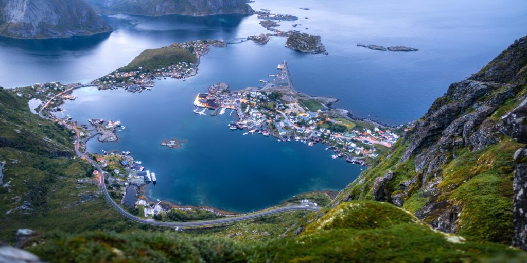
5. Reinebringen Ridge Hike
Reinebringen Ridge is one of Norway’s most picturesque and sought-after hikes, and it is nestled in the heart of the Lofoten Islands.
This trail offers hikers like you the chance to ascend a steep ridge that rewards your effort with panoramic views of the charming fishing village of Reine, the surrounding fjords, and the rugged peaks of the Lofoten archipelago.
Trail Snapshot
Difficulty: Moderate–Challenging
Distance: 1.5 km round trip
Elevation Gain: ~350 m
Start / End: Reine village
Highlights: Lofoten views, steep staircase climb
Difficulty/Recommended Fitness Level
Overall, the Reinebringen Ridge Hike is ideal for hikers with a good level of fitness and some hiking experience. The trail includes a steep ascent and narrow paths that require careful footing and steady pacing.
Distance
Covering approximately 1.5 kilometers (0.9 miles) round trip, the Reinebringen Ridge Hike is a relatively short but intense trek that typically takes around 1.5 to 2 hours to complete in total.
Elevation Gain
The hike features an elevation gain of about 350 meters (1,148 feet).
Start and End Point
The hike begins at the parking area near Reine, which is a picturesque fishing village in the Lofoten Islands. From the parking spot, you will follow well-marked paths that lead you through scenic landscapes. The trail loops back to the starting point.
Get to the Trailhead
Accessible by car in the Lofoten Islands. Parking is limited.
Highlights & Landmarks
Views over Reine’s red cabins and fjords are iconic.
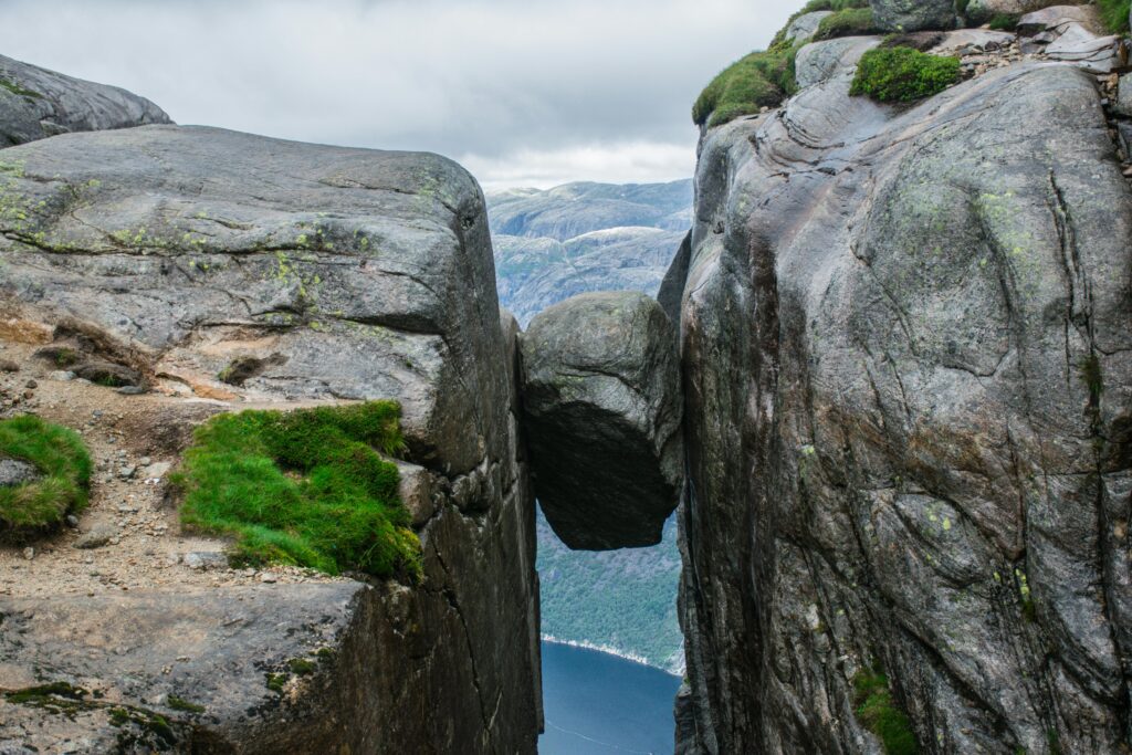
6. Kjeragbolten Hike
Kjeragbolten is one of Norway’s most visually striking hiking destinations, and it is located in the Lysefjord region.
This hike is perfect for those of you seeking a memorable adventure with a touch of excitement and some of Norway’s most dramatic scenery.
Trail Snapshot
Difficulty: Challenging
Distance: 12 km round trip
Elevation Gain: ~600 m
Start / End: Øygardstøl
Highlights: suspended boulder, fjord cliffs
Difficulty/Recommended Fitness Level
The trail includes steep ascents, rocky paths, and exposed sections that will require careful footing and a steady pace on your part.
While the hike is challenging, the well-marked paths and the exhilarating views from Kjeragbolten make it a rewarding trek for dedicated outdoor enthusiasts.
Distance
Covering approximately 12 kilometers (7.5 miles) round trip, the Kjeragbolten Hike is a substantial trek that typically takes around 6 to 8 hours to complete.
Elevation Gain
The hike features an elevation gain of about 600 meters (1,969 feet) in total.
Start and End Point
The hike begins at Øygardstøl, a mountain lodge located near the base of Kjerag.
From the lodge, you will follow well-marked paths that lead you through lush valleys and up steep slopes, before eventually reaching the dramatic cliffs where Kjeragbolten awaits.
Get to the Trailhead
Accessible by car during summer months. Road access is seasonal.
Highlights & Landmarks
Kjeragbolten is a boulder wedged between cliffs. It’s one of Norway’s most thrilling photo spots.
What to Bring for Hiking in Norway
Here’s what you’ll want to remember to pack when you go hiking in Norway:
Footwear
A sturdy pair of hiking boots is absolutely necessary for tackling Norway’s trails, which can vary from rocky mountain paths to muddy forest routes.
Waterproof boots are a smart choice, especially if you plan to explore areas near waterfalls or along fjords where you might encounter wet conditions.
Clothing
Norway’s weather can be unpredictable, so layering is a good idea to staying comfortable on the trails.
In cold water, start with a moisture-wicking base layer to keep sweat away from your skin.
Then you can add an insulating mid-layer (like a fleece) to help retain warmth, and then you can top it off with a lightweight and waterproof jacket to protect against rain and wind.
Backpack Essentials
A comfortable backpack is a must for carrying all your gear. Be sure to pack plenty of water to stay hydrated, especially on longer hikes.
High-energy snacks such as energy bars, nuts, and fruit will keep your energy levels up. It’s also a good idea to bring a small first-aid kit, a map or GPS device, and a multi-tool.
Other Essentials
Don’t overlook the little things that can make your hike smoother and more enjoyable. Sunglasses and sunscreen are important for protecting against the sun, even on cloudy days.
Insect repellent can be a lifesaver during the summer months, particularly in forested or marshy areas. The bugs in Norway can get thick!
🗒️ Free Checklist: “Pack light, pack right — download The Ultimate Hiking Packing List.”
Walking Holidays in Norway
Walking Holidays in Norway
If you’re looking to turn these hikes into a longer adventure, Norway is an excellent destination for a walking holiday.
You’ll find everything from hut-to-hut trekking routes in Jotunheimen to multi-day fjord adventures with breathtaking daily views. The country’s well-maintained trail network and mountain huts make it surprisingly accessible despite its wild landscapes.
Explore more: Walking Holiday in Norway
“Plan less, walk more.” Pick a route, set your pace, and let Norway unfold step by step.
“Plan less, walk more.” Pick a route, set your pace, and let Europe unfold under your boots: grab your free Walking Holiday ebook today”
Conclusion
Norway is truly a hiker’s dream come alive because it offers trails that ignite the spirit of adventure in every explorer. These trails will not only push your physical boundaries but also immerse you in the rich ancient folklore and the awe-inspiring geological wonders.
Where to Next?
If Norway has sparked your appetite for dramatic landscapes, here are a few more destinations worth exploring:
Nearby Nordic Adventures
Wider European Hiking Inspiration
- Best Hikes in Switzerland
- Best Hikes in Austria
- Hiking in the Alps: Trails, Gear, Seasons & What to Expect


