
Serbia’s hiking landscape is incredibly diverse. From the forested plateaus of Tara National Park to the rugged peaks of Stara Planina and the dramatic cliffs of the Iron Gates along the Danube, the country offers a wide range of hiking experiences.
One of Serbia’s greatest advantages is how uncrowded its trails remain. Many of the best hikes feel remote and peaceful, even inside popular national parks.
Combined with welcoming villages, rich cultural heritage, and spectacular viewpoints, Serbia offers one of the most underrated hiking destinations in Europe.
Quick Picks: Best Hikes in Serbia
If you want a quick overview before diving into the trail details, these hikes showcase some of the most spectacular landscapes Serbia has to offer — from dramatic river gorges to rugged Balkan mountain peaks.
Best scenic viewpoint – Banjska Stena Trail (Tara National Park) (iconic views over the Drina River canyon)
Best forest hike – Mitrovac to Banjska Stena Trail (dense forests and panoramic viewpoints in Tara National Park)
Best summit hike – Pančić’s Peak Trail (Kopaonik National Park) (Serbia’s highest mountain and sweeping alpine views)
Best cultural hike – Krčmar Loop Trail (Fruška Gora National Park) (historic monasteries and peaceful forest trails)
Best challenging mountain hike – Midžor Peak Trail (Stara Planina) (Serbia’s highest peak and rugged Balkan mountain scenery)
Best river gorge hike – Iron Gates Trail (Đerdap National Park) (dramatic Danube cliffs and ancient Roman history)
Why Hike in Serbia
Serbia may not be the first destination that comes to mind for hiking, but it’s a hidden gem that’s packed with some really incredible trails that can rival the Swiss or Austrian Alps.
Located right in the heart of the Balkans, and bordered by countries like Hungary, Romania, Bulgaria, Croatia, Bosnia and Herzegovina, Montenegro, and North Macedonia, Serbia offers diverse landscapes that range from dense forests to towering mountain peaks.
The best part? Many of these trails are still off the beaten path, so hikers like yourself can experience stunning scenery without the crowds.
Let’s take a look at some of the best trails this country has to offer!
Companion Article: Ultimate Guide to Hiking in Serbia
Serbia is just one part of the incredible hiking opportunities across the Balkans. From Montenegro’s Durmitor peaks to Albania’s Accursed Mountains, the region offers some of Europe’s most dramatic landscapes.
Read our Ultimate Guide to Hiking in Serbia to plan a broader regional adventure.
“Avoid rookie mistakes. Our free ebook Hiking for Beginners shows you how.”
The Best Hikes in Serbia
Serbia’s mountains, forests, and dramatic river gorges offer a wide range of hiking experiences across the country.
Below are some of the best hikes in Serbia, from panoramic viewpoints in Tara National Park to rugged summit climbs in Stara Planina.
Tara National Park (Banjska Stena Trail)
The Banjska Stena Trail in Tara National Park is one of the most stunning hikes Serbia has to offer, and it provides sweeping views of the Drina River and the surrounding mountains.
Located in the heart of one of the country’s most famous national parks, this trail combines breathtaking scenery with a touch of history!
Trail Snapshot
Difficulty: Moderate
Distance: 7 km round trip
Elevation Gain: ~400 m
Start / End: Tara National Park → Banjska Stena viewpoint
Highlights: Drina River canyon views, forest trails, dramatic viewpoints
Difficulty/Recommended Fitness Level
This trail is moderate in difficulty, which makes it suitable for hikers with a basic to intermediate fitness level.
While there are some steep sections, the path is well-maintained, and it’s manageable for those who are used to hiking or walking on uneven terrain!
Distance
The Banjska Stena Trail covers about 7 kilometers (4.3 miles) round trip. It usually takes around 3 to 4 hours to complete in total.
Elevation Gain
With an elevation gain of around 400 meters (1,312 feet), this hike offers a decent climb that’ll get your heart pumping without being too challenging.
Start and End Point
The trail begins at the Banjska Stena viewpoint, which is easily accessible from the main road through Tara National Park.
From there, you’ll need to follow the well-marked path that takes you through dense forests and up to the scenic viewpoint overlooking the Drina River. You’ll return the same way!
Get to the Trailhead
The trailhead is accessible by car from Bajina Bašta. Parking is available near the start of the route.
Highlights & Landmarks
One of the standout features of this hike is the Banjska Stena viewpoint itself. Offering panoramic views of the Drina River and the surrounding mountains, it’s a spot that’s often referred to as one of the most beautiful in Serbia.
Tara National Park is also rich in history, with remnants of medieval fortresses scattered throughout the area. It’s a little known fact that Serbia has quite the history in regards to the MIddle Ages!

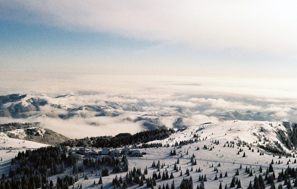
Mitrovac to Banjska
For those looking for a moderate hike with incredible views, the Mitrovac to Banjska Stena Trail is a must in Tara National Park.
This well-marked trail offers an immersive experience in the park’s dense forests and leads to one of its most iconic viewpoints.
Along the way, hikers like yourself will be treated to breathtaking panoramas of the Drina River Canyon and Lake Perućac.
Trail Snapshot
Difficulty: Moderate
Distance: 7 km round trip
Elevation Gain: ~400 m
Start / End: Mitrovac Tourist Center
Highlights: Drina River canyon, forest trails, Tara National Park scenery
Difficulty/Recommended Fitness Level
This trail is considered moderate in difficulty, which makes it ideal for hikers who have a basic to intermediate fitness level. The path is well-maintained with some gradual ascents and descents, so it’s got some good variety!
Distance
The hike is about 7 kilometers (4.3 miles) round trip, which typically takes around 2.5 to 3.5 hours to complete in total.
Elevation Gain
With an elevation gain of around 400 meters (1,312 feet), this hike provides a moderate challenge that is manageable for most folks.
Start and End Point
The trail starts at the Mitrovac Tourist Center, which is a popular starting point for many of the hikes in Tara National Park.
This trail offers another wayto reach the Banjska Stena viewpoint, than the Banjska Stena Trail
The route is out-and-back, so you’ll return the same way to the starting point.
Get to the Trailhead
Mitrovac is easily accessible by car from Bajina Bašta or Užice.
Highlights & Landmarks
Banjska Stena is famous for its stunning panoramic views of the Drina River Canyon and Lake Perućac, which easily makes it one of the best spots in the park for photos and simply taking in the beauty of the area.
As you hike, you’ll get to encounter the Drina River, which has carved the canyon over millennia, which adds a rich geological history to this hike as well!
Kopaonik National Park (Pančić’s Peak Trail)
For those who want to experience Serbia’s tallest mountain and enjoy incredible panoramic views, the Pančić’s Peak Trail in Kopaonik National Park is a definitive must.
This trail takes you to the summit of Pančić’s Peak, which is named after the famous Serbian botanist and where you’ll be rewarded with sweeping views of the surrounding mountains and valleys.
Trail Snapshot
Difficulty: Moderate–Challenging
Distance: 4.5 km round trip
Elevation Gain: ~600 m
Start / End: Kopaonik Ski Resort
Highlights: Serbia’s highest mountain views, alpine meadows, summit monument
Difficulty/Recommended Fitness Level
This hike is moderate to challenging, which makes it suitable for hikers with a solid fitness level.
The trail involves some steep sections, especially near the summit, but it’s well-marked and manageable for those of you who are accustomed to mountain hiking (and hopefully, that includes you!).
Distance
The Pančić’s Peak Trail is about 4.5 kilometers (2.8 miles) round trip. It usually takes around 2.5 to 3 hours to complete.
Elevation Gain
This hike has an elevation gain of about 600 meters (1,968 feet), so expect a steady climb, and especially as you approach the peak. The ascent is a bit steep in parts.
Start and End Point
The trail begins at the Kopaonik Ski Resort, which is a popular base for hikers and skiers alike. From there, you’ll need to follow the well-marked trail that takes you to the top of Pančić’s Peak. Once you reach the summit, you’ll be able to enjoy the incredible views!
Get to the Trailhead
Kopaonik National Park is accessible by car or bus from Belgrade or Niš.
Highlights & Landmarks
One of the highlights of the Pančić’s Peak Trail is the panoramic views from the summit, which offer a 360-degree look at Kopaonik National Park, the rolling hills of central Serbia, and on a clear day, even as far as Kosovo!
Along the way, you’ll pass through lush forests and alpine meadows that will make you think you’re in the Alps.
Fruska Gora National Park (The Krčmar Loop Trail)
If you’re looking for a peaceful and scenic hike that offers a mix of history and nature, the Krčmar Loop Trail in Fruška Gora National Park is an excellent choice.
This trail winds through dense forest and past traditional Serbian monasteries, and it also provides plenty of opportunities for wildlife spotting and relaxation. Located just a short drive from Novi Sad, it’s the perfect escape into nature.
Trail Snapshot
Difficulty: Easy–Moderate
Distance: 8 km round trip
Elevation Gain: ~250 m
Start / End: Krčmar village
Highlights: forest trails, Serbian monasteries, wildlife
Difficulty/Recommended Fitness Level
This hike is easy to moderate, which makes it perfect for hikers of all levels, including families or those looking for a more relaxed day in nature. The trail is mostly flat with gentle ascents.
Distance
The Krčmar Loop Trail is around 8 kilometers (5 miles) round trip. You can expect to complete it in about 2 to 3 hours.
Elevation Gain
With an elevation gain of about 250 meters (820 feet), this hike is fairly gentle, which makes it accessible to most hikers.
Start and End Point
The trail starts at the village of Krčmar, which is located within the heart of Fruška Gora National Park. From there, you will need to follow the marked path that loops through the forest and along the monasteries. The trail is out-and-back.
Get to the Trailhead
Fruška Gora is a short drive from Novi Sad, making it a popular day hike destination.
Highlights & Landmarks
Fruška Gora is often called “the Mount of the Monasteries” because it is home to no less than 16 Serbian Orthodox monasteries.
Along the Krčmar Loop Trail, you can visit some of these historical gems, like the Rača Monastery, which dates back to the 13th century. The area is also rich in wildlife, with plenty of birds, deer, and rabbits to spot.
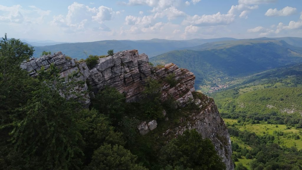
Stara Planina (The Midžor Peak Trail)
For experienced hikers looking for a challenge with some of the best views Serbia has to offer, the Midžor Peak Trail in Stara Planina is a must.
As the highest peak in the range, Midžor stands at an impressive 2,169 meters (7,116 feet), offering breathtaking panoramic views of the surrounding mountains and valleys.
This hike takes you deep into one of Serbia’s most rugged and wild mountain regions, where you’ll be surrounded by pristine nature and towering cliffs.
Trail Snapshot
Difficulty: Challenging
Distance: 14 km round trip
Elevation Gain: ~1,200 m
Start / End: Babin Zub village
Highlights: Serbia’s highest peak, alpine scenery, Balkan mountain views
Difficulty/Recommended Fitness Level
This hike is challenging, best suited for experienced hikers with a strong fitness level. The terrain is rough, with steep ascents, rocky paths, and some scrambling required in parts of the trail.
It’s a full-day hike, so only those who are used to long and strenuous climbs should attempt it.
Distance
The trail to Midžor Peak is approximately 14 kilometers (8.7 miles) round trip. Expect to spend around 6 to 7 hours on the trail, depending on your pace and how much time you take to enjoy the views along the way.
Elevation Gain
With an elevation gain of around 1,200 meters (3,937 feet), this hike is a serious workout. The ascent is steep and will require stamina on your part, so be ready!
Start and End Point
The hike begins at the village of Babin Zub, which is located at the base of Stara Planina. From there, you’ll follow the well-marked trail that leads you up through alpine meadows, dense forests, and rocky paths to the summit of Midžor.
The trail is out-and-back, so you’ll return the same way.
Get to the Trailhead
Babin Zub is reachable by car from Niš or Pirot.
Highlights & Landmarks
Midžor Peak is a highlight not just for its stunning views but also for the diverse ecosystems it offers.
The trail takes you through parts of Stara Planina, which is home to rich biodiversity, including rare plant species and wildlife such as bears and lynx.
The peak itself offers a 360-degree view of Serbia’s wild southeastern region and even glimpses of Bulgaria and Romania.
The rugged beauty of the area, combined with the challenge of the hike, makes this an unforgettable experience for those seeking an adventure in one of Serbia’s most untouched mountain regions.
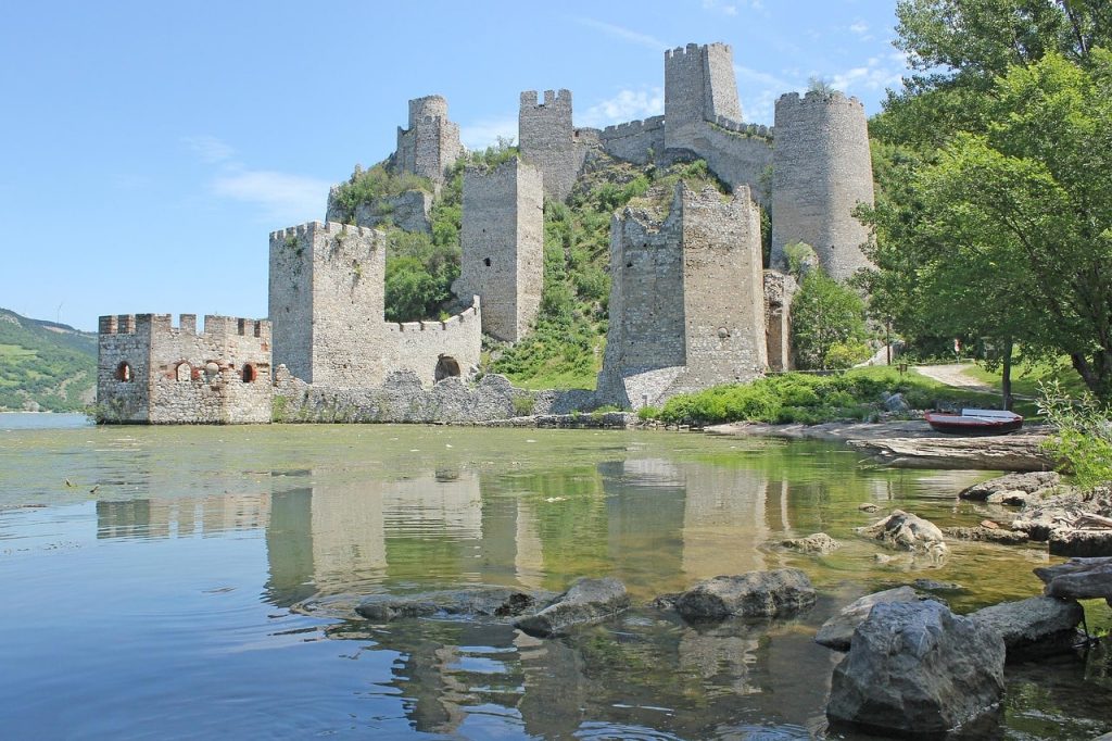
Đerdap National Park (The Iron Gates Trail)
This trail takes you along the famous Iron Gates, which is a dramatic river gorge formed by the Danube River between Serbia and Romania.
As you hike, you’ll experience incredible views of the river, the surrounding cliffs, and the historic remnants of ancient civilizations that once called this area home.
Trail Snapshot
Difficulty: Moderate
Distance: 9 km round trip
Elevation Gain: ~350 m
Start / End: Donji Milanovac
Highlights: Danube River gorge, Roman ruins, dramatic cliffs
Difficulty/Recommended Fitness Level
This hike is moderate, which makes it suitable for hikers with a basic to intermediate fitness level. While the trail isn’t too steep, there are some uneven sections and rocky paths, so it’s ideal for those of you who enjoy a scenic yet manageable hike.
Distance
The Iron Gates Trail covers about 9 kilometers (5.6 miles) round trip. It typically takes around 3 to 4 hours to complete in total.
Elevation Gain
With an elevation gain of around 350 meters (1,148 feet), the hike is moderate in terms of difficulty. The ascent is gradual.
Start and End Point
The trail starts near the village of Donji Milanovac, which is a small town that is located within Đerdap National Park. From there, the path leads you along the river’s edge. This trail is out-and-back as well.
Get to the Trailhead
The park can be reached by car from Belgrade in about three hours.
Highlights & Landmarks
The Iron Gates is not only a stunning natural wonder but also a region rich in history. Along the trail, you’ll pass by ancient ruins, including remnants of Roman fortifications and other historical sites dating back to the Roman Empire.
The Iron Gates themselves have served as a strategic waterway for centuries, and as you hike, you’ll see some of the oldest known rock carvings in Europe.
Essential Items for Hiking in Serbia
Footwear
Sturdy hiking boots or trail shoes are a must. Many of Serbia’s trails involve rocky or uneven ground, especially in mountain regions like Tara National Park or the Kopaonik Mountains.
Make sure your footwear provides ankle support and a solid grip to handle the rougher parts of the trail.
Clothing
Serbia’s weather can change quickly (particularly in the mountains), so dressing in layers is always a smart idea. You can opt for moisture-wicking base layers that will keep you comfortable as temperatures rise or fall.
Or, if you’re heading up higher elevations, it’s a good idea to bring a windproof or waterproof jacket, as conditions can be unpredictable!
Backpack Essentials
A small daypack should be enough for most hikes in Serbia. Be sure to pack at least 1 to 1.5 liters of water, along with some high-energy snacks and a basic first-aid kit.
A map or a GPS device can also be helpful, especially for longer or less-marked trails. And while mobile signal is generally reliable in this country, it’s always smart to have offline maps or a compass as a backup!
Other Essentials
Don’t forget the basics: sunscreen, a hat, and sunglasses are a must for sunny days. Insect repellent can also come in handy if you’re hiking through more wooded or marshy areas.
If you’re hiking during the early morning or evening, a headlamp or flashlight will help guide your way.
🗒️ Free Checklist: “Pack light, pack right — download The Ultimate Hiking Packing List.”
Walking Holidays in Serbia
Serbia offers excellent opportunities for multi-day walking holidays, particularly in national parks like Tara, Kopaonik, and Stara Planina. These regions combine mountain landscapes with traditional villages and cultural landmarks.
Many travelers base themselves in small mountain towns where guesthouses provide accommodation and local cuisine. From there, day hikes can be linked together to create longer trekking itineraries across forests, ridges, and river valleys.
Because Serbia remains relatively undiscovered compared to Western Europe’s hiking hotspots, walking holidays here feel peaceful and authentic.
You can experience stunning scenery, rich Balkan culture, and welcoming hospitality — all without crowded trails.
“Plan less, walk more.” Pick a route, set your pace, and let Europe unfold under your boots: grab your free Walking Holiday ebook today”
Conclusion
Serbia is truly an incredible country to visit for a hiking adventure. There is no shortage of fun and incredible hikes to do here, and there are many areas of the country that will make you think you’re in the Rocky Mountains of America or the Alps. You’ll need to see it to believe it!
Where to Next?
If Serbia has sparked your interest in exploring the wild landscapes of the Balkans, these destinations offer even more dramatic mountains, national parks, and scenic hiking routes.
More Hiking in the Balkans
Best Hikes in Montenegro (Durmitor National Park, alpine lakes, and dramatic mountain peaks)
Best Hikes in Albania (rugged Accursed Mountains and remote Balkan valleys)
Best Hikes in Bulgaria (Rila and Pirin mountain trails with glacial lakes and alpine scenery)
Best Hikes in North Macedonia (spectacular lakeside and mountain trails around Ohrid and Mavrovo)
Wider European Hiking Inspiration
Best Hikes in Germany (fairytale forests, sandstone cliffs, and scenic long-distance trails)
Best Hikes in France (Alpine hikes, coastal Mediterranean trails, and dramatic mountain scenery)
Best Hikes in the Netherlands (peaceful countryside walks and scenic coastal paths)
Walking Holidays in Scotland (historic mountain routes and scenic countryside trails)


