Malta may be small, but it offers some of the most unique hiking trails in the Mediterranean, with dramatic limestone cliffs, hidden coves, prehistoric temples, and historic coastal fortifications.
This guide covers six of the best hikes in Malta, including the cliff-top Dingli Cliffs Trail, the historic Victoria Lines ridge walk, and the scenic Comino coastal route around the Blue Lagoon.
Quick Picks: Best Hikes in Malta
If you’re short on time, these standout trails highlight Malta’s most scenic landscapes — from cliff-top coastal walks to historic ridge trails and island escapes.
Best coastal cliffs – Dingli Cliffs Coastal Trail (Malta’s most dramatic sea views)
Best historic hike – Victoria Lines Trail (Malta’s “Great Wall” ridge walk)
Best island adventure – Comino Coastal Trail (Blue Lagoon and hidden coves)
Best beach hike – Għajn Tuffieħa to Golden Bay Coastal Trail (cliff paths and sandy bays)
Best sea cave views – Blue Grotto Coastal Trail (arches and turquoise waters)
Best heritage hike – Ħaġar Qim & Mnajdra Heritage Walk (prehistoric temples and cliffs)
Why Hike in Malta
Are you thinking about visiting the Mediterranean and want to go on some hiking trails while you’re there? If so, you should check out Malta.
Malta isn’t like other Mediterranean countries such as Greece, Italy, France, Spain, or Croatia. It’s way more compact, packed with surprises, has lots of overlooked history, and it’s also it’s just downright quirky!
So while those bigger destinations may draw hikers with sprawling mountain ranges and legendary coastal routes, Malta’s charm lies in its intimate backcountry.
Think rugged sea‑cliffs you can scale in an hour, secret coves tucked behind limestone ridges, and ancient watchtowers that feel like they were built just for you to snap the perfect Instagram shot.
So for those of you who love discovering hidden gems off the beaten path, you’ll be glad to hear that Malta delivers in spades. One moment you’re wandering through fragrant fields of wild thyme and poppies; the next, you’re staring down at turquoise waters from a dizzyingly high bluff.
And because the island is so small, you can go from a sunrise hike overlooking Gozo’s jagged coastline to an afternoon stroll around Mdina’s medieval walls…all in a single day.
So forget the crowds and the long drives because Malta’s trails are short on distance but massive on character. Are you ready to find out more?
Companion Article: Ultimate Guide to Hiking in Malta
Before you lace up your boots, read our complete guide covering the best seasons, heat safety tips, transport logistics, and how to combine Malta and Gozo into a single hiking itinerary.
Check out the Ultimate Guide to Hiking in Malta to plan smarter.
“First time on the trail? Hiking for Beginners has your back.”
The Best Hikes in Malta
Now let’s dive into the top six hikes that Malta offers:
Dingli Cliffs Coastal Trail
Dingli Cliffs Coastal Trail is Malta’s ultimate “wow” hike. Imagine towering limestone cliffs plunging into the sparkling Mediterranean below, wildflowers dancing in the breeze, and unobstructed views all the way to Sicily on a clear day.
It’s the perfect introduction to Malta’s backcountry for anyone who loves epic seaside scenery without needing to trek for days, so if that includes you, you’re in for a fun little adventure!
Trail Snapshot
Difficulty: Easy–Moderate
Distance: 8 km round trip
Elevation Gain: ~200 m
Start / End: Dingli Cliffs car park
Highlights: Limestone cliffs, WWII observation posts, San Dimitri Chapel
Difficulty/Recommended Fitness Level
Overall, this trail is easy to moderate, which makes it ideal for hikers of most fitness levels. The path is well‑marked and mostly flat, with just a few gentle climbs that add a touch of challenge without wearing you out.
Distance
Covering approximately 8 kilometers (5 miles) round trip, the Dingli Cliffs loop can comfortably be completed in three to four hours. That’s plenty of time to pause, snap photos, and simply soak in the views.
Elevation Gain
The hike features a modest elevation gain of about 200 meters (656 feet), which provides enough ascent to earn those sweeping vistas and without feeling like a steep mountain climb.
Start and End Point
The adventure begins and ends at the Dingli Cliffs car park, where you’ll find parking, basic facilities, and clear trail signage. From there, follow the coastal path as it winds along the cliff edge.
Get to the Trailhead
Accessible by car or bus from Valletta or Mdina. Parking is available near the viewpoint.
Highlights & Landmarks
Towering cliffs plunge into the sea below. Along the way, you’ll pass historic military posts and the small San Dimitri Chapel.
Blue Grotto Coastal Trail
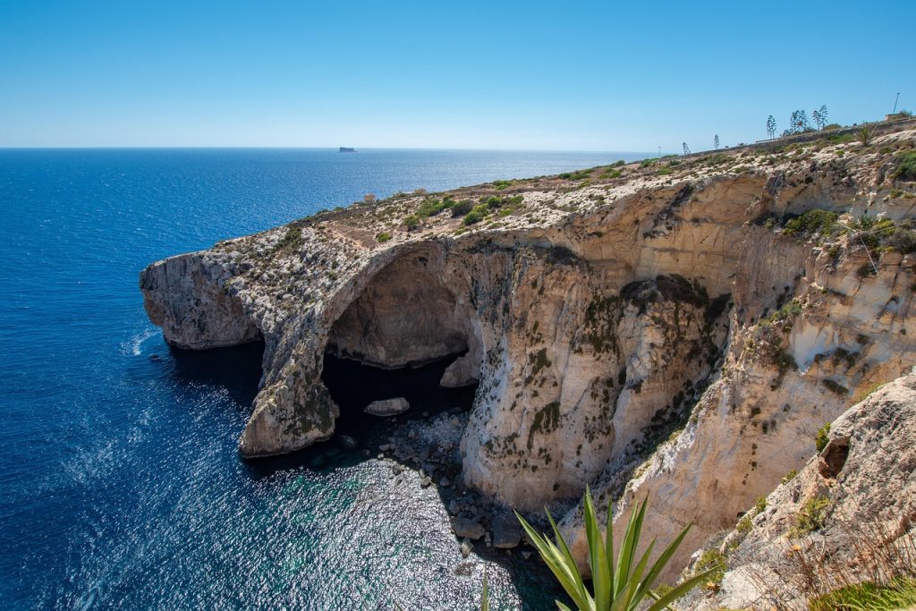
Blue Grotto Coastal Trail is a must‑do for anyone who loves dramatic sea views and hidden caves with a subtle splash of Maltese coastal charm.
This easy‑to‑moderate hike hugs the southern shoreline, and it leads you past towering limestone cliffs that plunge into brilliantly turquoise waters and offering countless photo ops of natural arches and sea caves.
Trail Snapshot
Difficulty: Easy–Moderate
Distance: 6 km round trip
Elevation Gain: ~150 m
Start / End: Wied iż-Żurrieq parking area
Highlights: Blue Grotto caves, sea arches, turquoise waters
Difficulty/Recommended Fitness Level
Overall, this trail is easy to moderate. It’s perfect for hikers of all abilities. The path is well‑defined with only gentle ups and downs, which makes it a relaxed stroll punctuated by stunning vistas.
Distance
Covering roughly 6 kilometers (3.7 miles) round trip, the Blue Grotto Coastal Trail can comfortably be completed in 2 to 3 hours, and it leaves plenty of time for exploration and seaside picnics.
Elevation Gain
The hike features a modest elevation gain of about 150 meters (492 feet), which provides enough climb to keep things interesting without ever feeling strenuous.
Start and End Point
Your adventure begins and ends at the Wied iż‑Żurrieq parking area. From there, the clearly marked paths guide you along the cliff edge toward the iconic Blue Grotto sea caves.
Get to the Trailhead
Accessible by car or bus from central Malta. Boat tours to the Blue Grotto depart nearby.
Highlights & Landmarks
The glowing Blue Grotto sea caves are the highlight. Traditional fishing boats and dramatic rock formations define the coastline.
Victoria Lines Trail
Victoria Lines Trail is a unique blend of history and scenery that takes you along Malta’s legendary “Great Wall,” a series of 19th‑century fortifications perched high on the island’s central ridge.
For those of you who love a dash of heritage with your hike, this trail delivers sweeping panoramic views of Malta’s countryside with some neat glimpses of distant harbors.
Trail Snapshot
Difficulty: Moderate
Distance: 11 km point-to-point
Elevation Gain: ~300 m
Start / End: Madliena Fort → Għargħur Tower
Highlights: 19th-century fortifications, countryside views, ridge walking
Difficulty/Recommended Fitness Level
Overall, the Victoria Lines Trail is moderate. This is perfect for hikers with a reasonable fitness level who enjoy steady walking over varied terrain. The path is well‑marked but includes some uneven surfaces and gentle climbs.
Distance
Covering approximately 11 kilometers (6.8 miles) round trip, this trek typically takes about 4 to 5 hours at a comfortable pace.
Elevation Gain
The hike features an elevation gain of around 300 meters (984 feet), and it offers gradual ascents that reward you with expansive views across Malta’s northern coastline and rugged interior.
Start and End Point
Your adventure begins at Madliena Fort (just north of Mosta) and ends at the Għargħur Tower, though you can pick up or drop off at several access points along the route for a shorter hike.
Get to the Trailhead
Best accessed by car or taxi. Public buses run near access points.
Highlights & Landmarks
Often called Malta’s “Great Wall,” the fortifications stretch across the island’s ridge. British military structures and sweeping panoramas dominate the experience.
Għajn Tuffieħa to Golden Bay Coastal Trail
Għajn Tuffieħa to Golden Bay Coastal Trail is a sun‑kissed slice of Maltese coastline that perfectly blends cliff‑top panoramas with sandy beach stops.
For those of you who love salty sea breezes and hidden coves with the chance to cool off with a refreshing dip halfway through, this trail delivers all the coastal magic in a single and scenic outing.
Trail Snapshot
Difficulty: Moderate
Distance: 6 km round trip
Elevation Gain: ~150 m
Start / End: Għajn Tuffieħa Bay car park
Highlights: Sandy beaches, limestone cliffs, WWII pillboxes
Difficulty/Recommended Fitness Level
Overall, this hike is moderate. It’s ideal for hikers comfortable with uneven terrain and short climbs but who still want a relaxed and beach‑friendly adventure.
Distance
Covering approximately 6 kilometers (3.7 miles) round trip, the trail can be completed in about 2 to 3 hours assuming that you’re walking at a leisurely pace.
Elevation Gain
The hike features a modest elevation gain of around 150 meters (492 feet), and it offers gentle ups and downs that reward you with sweeping views of Malta’s rugged northwest coast.
Start and End Point
Begin at the Għajn Tuffieħa Bay car park (look for the clearly marked trailhead) and follow the coastal path west until you reach the golden sands of Golden Bay. Then you’ll return the same way for an easy round trip!
Get to the Trailhead
Accessible by car or bus from Valletta and northern Malta.
Highlights & Landmarks
Ancient cart ruts, WWII defenses, and sweeping beach views define the trail. Golden Bay offers a refreshing swim at the turnaround point.
Comino Coastal Trail
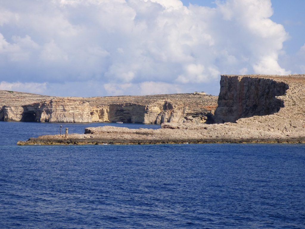
Comino Coastal Trail proves that great adventures don’t have to cover miles. This tiny island packs a huge scenic punch with its crystal‑clear waters, dramatic sea cliffs, and hidden coves.
It’s the perfect trail for those of you who want a taste of Maltese island life without straying far from the famous Blue Lagoon.
Trail Snapshot
Difficulty: Easy
Distance: 6 km round trip
Elevation Gain: ~100 m
Start / End: Blue Lagoon ferry landing
Highlights: Santa Marija Tower, Blue Lagoon, hidden coves
Difficulty/Recommended Fitness Level
Overall, this hike is easy — ideal for families, casual walkers, and anyone who prefers gentle terrain paired with spectacular views.
Distance
Covering approximately 6 kilometers (3.7 miles) round trip, the Comino Coastal Trail can be completed in about 2 to 3 hours at a relaxed pace, which leaves plenty of time for swimming stops.
Elevation Gain
The hike features a modest elevation gain of around 100 meters (328 feet), and it offers gentle climbs that reward you with sweeping vistas of turquoise bays.
Start and End Point
Your adventure begins and ends at the Comino ferry landing (Blue Lagoon), where clearly marked paths guide you clockwise around the island to Santa Marija Bay and back.
Get to the Trailhead
Reach Comino via ferry from Malta or Gozo.
Ferries to Comino depart regularly from Malta and Gozo, with schedules available through Malta’s official tourism portal.
Highlights & Landmarks
Santa Marija Tower overlooks dramatic cliffs. Crystal-clear waters and secluded coves make this trail uniquely scenic.
Ħaġar Qim & Mnajdra Heritage Walk
Ħaġar Qim & Mnajdra Heritage Walk offers a captivating journey into Malta’s prehistoric past.
This trail guides you along dramatic cliff edges where you’ll marvel at two of the island’s most iconic megalithic temple complexes, and all while enjoying sweeping views of the Mediterranean and the timeless allure of ancient legends.
Trail Snapshot
Difficulty: Moderate
Distance: 7 km round trip
Elevation Gain: ~200 m
Start / End: Ħaġar Qim Visitor Centre
Highlights: Megalithic temples, coastal cliffs, archaeological heritage
Difficulty/Recommended Fitness Level
Overall, this hike is best suited for those with a moderate level of fitness.
The path features a mix of well‑trodden sections and a few uneven, rocky stretches, which makes it accessible for adventurous families and casual hikers alike while still offering a bit of a challenge.
Distance
Covering approximately 7 kilometers (4.3 miles) round trip, the Ħaġar Qim & Mnajdra Heritage Walk is an ideal half‑day adventure that lets you fully explore the site and its stunning surroundings without feeling rushed.
Elevation Gain
The trail features a modest elevation gain of about 200 meters (656 feet), and it offers a gradual climb that will then steadily reward you with breathtaking panoramic vistas of ancient ruins and the deep blue sea beyond.
Start and End Point
The adventure begins and ends at the Ħaġar Qim Visitor Centre, which happens to be conveniently located near the temple complex in Qrendi.
From here, the clear trail markers will lead you along the coast to both Ħaġar Qim and Mnajdra.
Get to the Trailhead
Accessible by car or bus from Valletta. Visitor facilities are available onsite.
Highlights & Landmarks
Ħaġar Qim and Mnajdra are over 5,000 years old. Few hikes in Europe combine coastal scenery with prehistoric temples so seamlessly.
What to Bring for Hiking in Malta
Malta’s main challenge is sun exposure rather than terrain.
Footwear
Malta’s backcountry is all about limestone cliffs, uneven rock slabs, and occasional loose gravel. That’s exactly why a sturdy pair of lightweight hiking shoes with excellent grip is a must.
Skip the flip‑flops (even though you’ll want them later for a dip) and choose shoes that dry quickly in case you scramble down to a hidden cove.
Clothing
Layers aren’t as crucial here as sun protection and breathability. You should opt for moisture‑wicking, quick‑dry shirts and shorts, plus a wide‑brimmed hat to shield your face from the fierce midday sun.
Even on cooler mornings or windy cliff tops, a lightweight windbreaker will keep you comfortable without weighing you down.
Backpack Essentials
A compact daypack is perfect for Malta’s shorter hikes. Pack at least 2 liters of water per person (since Malta’s heat can very quickly sneak up on you) and high‑energy snacks like nuts or dried fruit.
Don’t forget a small first‑aid kit, a detailed trail map (phone signal can be spotty), and a portable charger for your phone or GPS.
Other Essentials
Sunscreen (SPF 30+), sunglasses, and lip balm with UV protection are non‑negotiable. In summer months, insect repellent will save you from pesky midges near valleys.
A lightweight towel or quick‑dry cloth comes in handy for spontaneous swims, and a headlamp is a smart addition if you plan to watch the sunset and hike back in fading light.
🗒️ Free Checklist: “Never forget the essentials — grab your free Ultimate Hiking Packing List.”
Walking Holidays in Malta
Malta is ideal for short walking holidays rather than multi-week trekking routes. Because distances are compact, you can base yourself in one location and explore different coastal trails each day.
A popular approach is combining Malta and Gozo into a 4- to 6-day itinerary. Spend a few days exploring Victoria Lines, Dingli Cliffs, and the southern coast, then ferry to Gozo for quieter countryside walks and dramatic sea arches.
Accommodation ranges from boutique hotels to rural farmhouses. Public transport is reliable, though renting a car increases flexibility.
Because trails are relatively short, walking holidays in Malta focus on variety rather than endurance — cliff walks, heritage trails, beach routes, and sunset hikes all within reach.
For hikers who love coastal landscapes and history without long alpine treks, Malta offers a balanced and highly accessible walking holiday.
“Plan less, walk more.” Pick a route, set your pace, and let Europe unfold under your boots: grab your free Walking Holiday ebook today”
Conclusion
And there you have it! Don’t let Malta’s small size or its ‘isolation’ in the middle of the Mediterranean fool you. Like you’ve seen, this little island country has a lot of great hiking trails that are definitely worth exploring.
Where to Next?
If Malta’s coastal cliffs and historic trails have sparked your interest, several nearby Mediterranean destinations offer equally spectacular hiking adventures.
Nearby Countries & Island Inspiration
Best Hikes in Sicily – Volcanoes, sea cliffs, and Mediterranean island scenery
Best Hikes in Greece – Island trails and dramatic coastal landscapes
Best Hikes in Croatia – Adriatic cliffs and historic coastal paths
Valletta: A City Guide for Hikers – Fortifications, viewpoints, and coastal walks
Wider Hiking Inspiration
Best Hikes in Spain – Diverse mountain and coastal hiking routes
Best Hikes in Austria – Alpine scenery and classic European mountain trails
Hiking the West Highland Way – Scotland’s most famous long-distance trek