

As a country, Belgium is definitely the most well known for its charming cities, chocolates, and medieval architecture.
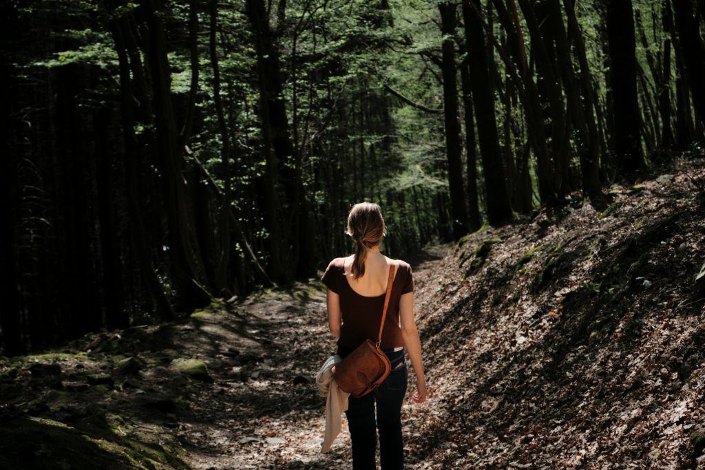
But as a hiker, don’t be fooled. This country also has some neat hiking experiences that will enable you to truly explore its natural beauty. The hikes here range from rugged hills to scenic river walks to peaceful forests to coastal trails by the sea.
If you’d like to learn more about the types of hiking trails that Belgium has to offer, read on!
Why Hike in Belgium?
Belgium is an excellent hiking destination for walkers who value variety, atmosphere, and ease. Trails wind through dense Ardennes forests, alongside winding rivers, across high moorlands, and even through coastal dunes. Many routes are looped, clearly signed, and easy to access by car or public transport.
The country’s mild elevation makes hiking approachable year-round, while seasonal highlights — like autumn forest colors or spring bluebell blooms — add character to each walk.
Belgium is especially well-suited to scenic day hikes, weekend trips, and slower-paced walking holidays that blend nature with history and local culture.
Companion Article: Ultimate Guide to Hiking in Belgium
If you’re planning a longer trip or want to understand Belgium’s hiking regions, seasons, and trail etiquette in more detail, our complete guide breaks everything down.
Read the Ultimate Guide to Hiking in Belgium for regions, trail types, and planning tips.
The Best Hikes in Belgium
Belgium’s best hikes showcase its quiet beauty — from wild moorlands and forest rivers to storybook villages and historic castles.
These routes range from easy walks to moderate full-day hikes, making them suitable for a wide range of fitness levels.
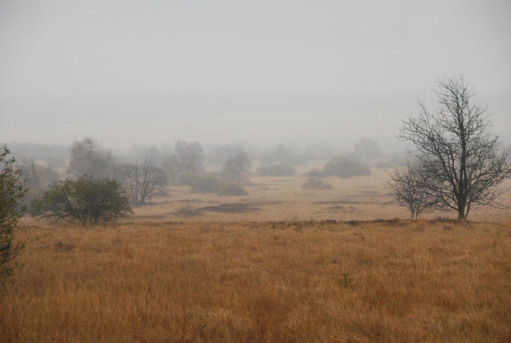
1. The High Fens (AKA the Hautes Fagnes)
The High Fens, or Hautes Fagnes, is one of the most striking natural landscapes in Belgium. Located in the eastern part of the country, near the German border, this nature park offers unique scenery with vast peat bogs, moorlands, and dense forests.
It’s a favorite for hikers who want to experience Belgium’s highest elevation and explore its wild, open spaces.
Trail Snapshot
• Difficulty: Moderate
• Distance: 6–14 km (3.7–8.7 mi)
• Elevation Gain: Minimal
• Start / End: Signal de Botrange Visitor Centre
• Highlights: Peat bogs, boardwalks, open moorland
Difficulty/Recommended Fitness Level
This hike is moderate and is suitable for hikers with a basic to moderate fitness level. The terrain is relatively flat but can be challenging due to the wetlands and boggy areas, especially after rain.
Distance
The hike offers a variety of trails, ranging from 6 km/3.7 miles to 14 km/8.7 miles, depending on your chosen route. The longer routes provide a more immersive experience in the heart of the nature reserve.
Elevation Gain
There is minimal elevation gain, with gentle undulations in the terrain. The highest point in Belgium, Signal de Botrange (694 meters/2276 feet), is located in the area, but overall, the hike itself is mostly flat.
Start and End Point
The starting point for many hikes in the High Fens is the Signal de Botrange visitor center, where several marked trails begin. The trails form loops, so you can return to your starting point with ease.
Get to the Trailhead
Signal de Botrange is reachable by car from eastern Belgium and nearby Germany.
Highlights & Landmarks
Raised wooden boardwalks crossing fragile peat bogs, wide-open landscapes, and Belgium’s highest point.
2. Ninglinspo Trail
The Ninglinspo Trail is one of Belgium’s most beautiful and adventurous hikes, and winds through the lush Ardennes forest along the banks of the Ninglinspo River.
Known for its cascading streams, waterfalls, and natural rock pools, this trail offers a nice escape into nature, and it should be a favorite amongst those of you who are looking for a scenic and refreshing experience.
Trail Snapshot
• Difficulty: Moderate
• Distance: 6 km (3.7 mi) loop
• Elevation Gain: 200 m (656 ft)
• Start / End: Sedoz (Aywaille)
• Highlights: Waterfalls, rock pools, forest paths
Difficulty/Recommended Fitness Level
This is a moderate hike, and will be ideal for those of you who have a basic to moderate level of fitness. While not overly difficult, the trail includes some rocky terrain, steep sections, and uneven paths. You’ll want some good boots or hiking shoes if you hike this one.
Distance
The trail is approximately 6 km/3.7 miles long, which makes it a pleasant half-day hike. You can extend the hike by exploring nearby trails or loops within the Ardennes forest.
Elevation Gain
The hike features around 200 meters/656 feet of elevation gain, with some short and steep climbs as the trail follows the river uphill.
Start and End Point
The hike starts from the parking area near the village of Sedoz, located in the municipality of Aywaille. The trail is a loop, leading you along the river and back to the starting point.
Get to the Trailhead
Accessible by car; parking available near the trail entrance.
Highlights & Landmarks
Belgium’s only mountain river, cascading streams, wooden bridges, and shaded forest scenery.
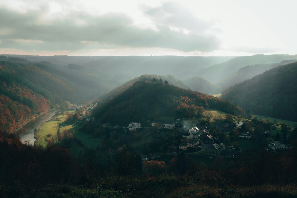
3. The Rochehaut Loop
The Rochehaut Loop is one of the most scenic and panoramic hikes in Belgium and offers breathtaking views of the Semois Valley and the quaint village of Frahan.
This hike combines picturesque landscapes with peaceful woodland paths, and it is a fantastic option for those who want to explore the beauty of the Ardennes.
Trail Snapshot
• Difficulty: Moderate
• Distance: 11 km (6.8 mi)
• Elevation Gain: 300 m (984 ft)
• Start / End: Rochehaut village
• Highlights: Semois Valley views, Frahan village
Difficulty/Recommended Fitness Level
This is a moderate hike suitable for hikers with a basic to moderate fitness level. There are some steep climbs and descents, particularly when hiking down to the river and back up to the viewpoint. But overall, it’s accessible for most hikers.
Distance
The Rochehaut Loop covers approximately 11 km/6.8 miles, so it is a great option for a half-day or full-day hike depending on your pace and how long you spend enjoying the views.
Elevation Gain
This hike includes about 300 meters/984 feet of elevation gain, with some steep sections as the trail descends into the valley and climbs back up to the Rochehaut viewpoint.
Get to the Trailhead
Drive to Rochehaut; parking available in the village.
Highlights & Landmarks
Panoramic viewpoints overlooking the Semois River and the village of Frahan below.
“First time on the trail? Hiking for Beginners has your back.”
4. Signal de Botrange Loop
Signal de Botrange, located in the Hautes Fagnes (High Fens), is the highest point in Belgium at 694 meters/2,277 feet.
This hike takes you through the unique and atmospheric landscape of peat bogs, windswept moorlands, and dense forests. It will offer you a completely different experience from the more traditional forested trails of the Ardennes.
Trail Snapshot
• Difficulty: Easy–Moderate
• Distance: 10 km (6.2 mi)
• Elevation Gain: 100 m (328 ft)
• Start / End: Signal de Botrange Visitor Centre
• Highlights: Moorland scenery, boardwalk paths
Difficulty/Recommended Fitness Level
This is an easy to moderate hike, ideal for all fitness levels. The terrain is mostly flat, but due to the nature of the wetlands, it can be muddy and challenging in places. Wooden boardwalks help to navigate the boggy sections.
Distance
The Signal de Botrange hike can vary in length depending on the route you choose, but the standard loop is approximately 10 km/6.2 miles, which should make it a pleasant half-day hike.
Elevation Gain
Though you’re at Belgium’s highest point, the hike itself has minimal elevation gain, around 100 meters/328 feet, since the landscape is relatively flat and expansive.
Start and End Point
The hike starts at the Signal de Botrange visitor center, where several well-marked trails begin. It’s a loop hike, so you’ll return to the same point after exploring the beautiful moorlands and forest paths of the High Fens.
Get to the Trailhead
Easy road access; well-marked trails from the centre.
Highlights & Landmarks
Atmospheric peat landscapes and the symbolic tower marking Belgium’s highest elevation.
5. Château de Bouillon & Semois River Trail
This hike offers a perfect blend of history and nature, taking you through the forested hills surrounding the medieval Chateau de Bouillon and along the scenic banks of the Semois River.
Combining stunning views, cultural landmarks, and peaceful riverside paths, it’s one of the most rewarding hikes in the Belgian Ardennes.
Trail Snapshot
• Difficulty: Moderate
• Distance: 9 km (5.6 mi)
• Elevation Gain: 250 m (820 ft)
• Start / End: Château de Bouillon
• Highlights: Medieval castle, river views
Difficulty/Recommended Fitness Level
This is a moderate hike that is suitable for hikers with a basic to moderate fitness level. There are some steep climbs and descents, especially near the castle and along the hills by the river, but it’s manageable for most people.
Distance
The loop covers about 9 km/5.6 miles, which makes it a great half-day hike with plenty of time to explore the castle and the surrounding natural beauty.
Elevation Gain
The trail has around 250 meters/820 feet of elevation gain, and with some short, steep climbs up the hills near the castle and around the river valley.
Start and End Point
The hike begins at the Chateau de Bouillon, which is located in the town of Bouillon. From there, the trail loops through the forested hills and alongside the Semois River before returning to the castle.
Get to the Trailhead
Bouillon is reachable by car; parking available near the castle.
Highlights & Landmarks
Historic fortress views, forested hills, and peaceful riverside walking.
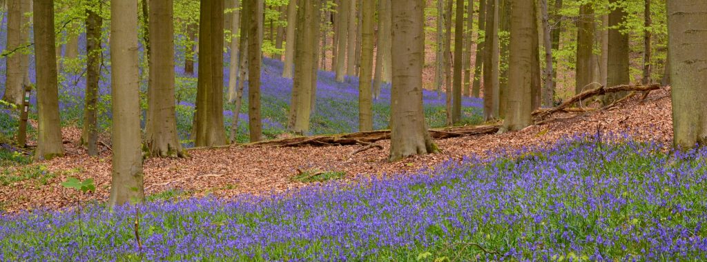
6. Hallerbos (Blue Forest) Trail
The Hallerbos, also known as the Blue Forest, is famous for its breathtaking display of bluebells that carpet the forest floor each spring.
This magical hike is especially interesting during the blooming season when the bluebells create a stunning sea of blue and violet.
Trail Snapshot
• Difficulty: Easy
• Distance: 7 km (4.3 mi)
• Elevation Gain: Minimal
• Start / End: Hallerbos parking areas
• Highlights: Bluebells, spring woodland scenery
Difficulty/Recommended Fitness Level
This is an easy hike that is perfect for all fitness levels, including families and casual walkers. The trails are well-maintained and mostly flat, which makes it accessible and enjoyable for anyone.
Distance
The main trail through Hallerbos is approximately 7 km/4.3 miles long, which makes it a relaxing half-day hike. There are also shorter and longer route options available depending on how much time you want to spend exploring.
Elevation Gain
There is minimal elevation gain on this hike, with only slight undulations throughout the forest, making it an easy and pleasant walk.
Start and End Point
The hike starts from one of the designated parking areas near Hallerbos, which is located just outside the town of Halle, about 30 minutes from Brussels. The trail is a loop and leads you through the most beautiful parts of the forest and back to the starting point.
Get to the Trailhead
About 30 minutes from Brussels by car.
Highlights & Landmarks
A spectacular springtime carpet of bluebells, one of Belgium’s most photographed natural events.
What to Bring for Hiking in Belgium
Before setting out on any hike in Belgium, it’s important to be prepared with the right gear and clothing to ensure a comfortable and enjoyable experience.
While Belgium’s terrain is generally more forgiving than mountainous regions, its weather can be unpredictable, and certain trails may require specific gear:
- Footwear
- A sturdy pair of hiking shoes or boots is essential, especially if you’re tackling trails with uneven terrain, like the Ardennes hills or any of the forested areas. For easier, flat walks, comfortable walking shoes with good grip will suffice. Since Belgium is known for its frequent rain, waterproof footwear is a smart choice to keep your feet dry on wet trails.
- A sturdy pair of hiking shoes or boots is essential, especially if you’re tackling trails with uneven terrain, like the Ardennes hills or any of the forested areas. For easier, flat walks, comfortable walking shoes with good grip will suffice. Since Belgium is known for its frequent rain, waterproof footwear is a smart choice to keep your feet dry on wet trails.
- Clothing
- Belgium’s weather can change quickly, so layering is very important. You should start out with a moisture-wicking base layer to keep sweat off your skin, and followed up by an insulating layer (such as fleece) to keep you warm. Always bring a waterproof and windproof outer layer, as rain can come unexpectedly, including during the warmer months.
- Backpack
- A comfortable backpack is crucial for carrying essentials like water, snacks, a map or GPS device, and extra layers of clothing. Even on shorter hikes, it’s a good idea to bring a small first-aid kit, sunscreen, and a reusable water bottle.
- Other Essentials
- Sunglasses and sunscreen are important, as Belgium’s mild weather can be deceptive. The sun, for instance, can still be strong, and particularly in open areas like coastal or hillside trails. If you’re planning to hike in more remote areas, having a fully charged phone or GPS device will be good for navigation.
🗒️ Free Checklist: “Pack light, pack right — download The Ultimate Hiking Packing List.”
Walking Holidays in Belgium
Belgium is well suited to relaxed walking holidays that combine nature with culture. Multi-day routes in the Ardennes link villages, forests, and river valleys, while flatter regions near Flanders and the coast are perfect for gentle, low-impact itineraries.
Walking holidays here often focus on short daily distances, comfortable accommodation, and local food experiences.
Many routes can be adapted for self-guided travel, making Belgium a great option for first-time European walking holidays or slower-paced trips.
“Plan less, walk more.” Pick a route, set your pace, and let Europe unfold under your boots: grab your free Walking Holiday ebook today”
Conclusion
Belgium may not be the first destination that comes to mind for hiking, but its varied landscapes and scenic trails make it a hidden gem for outdoor enthusiasts. Any one of the above six trails we’ve covered here today will be a fun experience.
Where to Next?
If you enjoyed hiking in Belgium, you might also like:


