

Slovenia is widely considered one of Europe’s best destinations for outdoor adventures. Much of the country is covered in forests and mountains, and nearly a third of Slovenia is protected as natural parkland.
The country’s hiking trails range from gentle lakeside walks to challenging alpine climbs in the Julian Alps. Many routes pass through pristine landscapes where hikers can encounter waterfalls, glacial lakes, and charming alpine villages.
Best of all, Slovenia’s trails remain far less crowded than those in neighboring Alpine countries, making it easier to experience nature in peace.
Quick Picks: Best Hikes in Slovenia
If you want a quick snapshot before diving into the trail details, these hikes highlight some of the most rewarding landscapes Slovenia has to offer.
Best summit hike – Triglav Summit Trail (Slovenia’s highest peak and classic Julian Alps adventure)
Best easy scenic hike – Lake Bled to Vintgar Gorge Trail (iconic lake views, forest paths, and a dramatic river gorge)
Best alpine lakes hike – Pokljuka Plateau to the Triglav Lakes (glacial lakes, alpine meadows, and classic Triglav National Park scenery)
Best ridge hike – Karavanke Ridge Trail (border ridge walking with wide Alpine views into Slovenia and Austria)
Best river trail – The Soča River Trail (emerald water, waterfalls, and First World War history)
Best cultural alpine walk – Velika Planina (traditional shepherd huts and panoramic Kamnik Alps views)
Why Hike in Slovenia
Slovenia may be small, but it’s packed with some of the most stunning hiking trails in Europe. It offers everything from towering mountain peaks to tranquil lakes and lush forests.
The beauty of Slovenia honestly lies in its diversity, which is something you may not have expected.
With its borders touching Italy to the west, Austria to the north, Hungary to the northeast, and Croatia to the south, you can experience a unique mix of Mediterranean, Alpine, and Karst landscapes, all within one small country!
And the best part?
Most of these trails are surprisingly uncrowded, which means you can enjoy Slovenia’s natural beauty in peace.
So, whether you’re in it for the challenge or just to enjoy some fresh air, Slovenia’s hiking trails will leave you with unforgettable memories.
Are you ready to explore?
Let’s dive together into some of the best hikes Slovenia has to offer!
Companion Article: Ultimate Guide to Hiking in Slovenia
Many of Slovenia’s best hiking routes lie within the stunning Julian Alps. This mountain range contains some of the most dramatic scenery in Central Europe, including Triglav National Park and the famous Soča Valley.
Read our Ultimate Guide to Hiking in Slovenia to discover the best routes, seasonal tips, and travel advice for exploring Slovenia’s mountains.
“First time on the trail? Hiking for Beginners has your back.”
The Best Hikes in Slovenia
Now let’s dive into the top six hikes that Slovenia offers:
Triglav Summit Trail
For the ultimate Slovenian hiking experience, the Triglav Summit Trail is a must. Standing at 2,864 meters (9,396 feet), Triglav is the highest peak in Slovenia and the crown jewel of Triglav National Park.
The challenge of summiting Triglav is well worth the effort for anyone who is looking for a memorable adventure, so if that includes you, get excited!
Trail Snapshot
Difficulty: Challenging
Distance: 10 km one way
Elevation Gain: ~1,800 m
Start / End: Aljaž Hut → Mount Triglav summit
Highlights: Slovenia’s highest peak, Julian Alps views, alpine scrambling
Difficulty/Recommended Fitness Level
This trail is challenging, so it’s recommended for experienced hikers or those with a good fitness base. The climb involves rocky paths, steep ascents, and some scrambling, and especially near the summit.
If you’re comfortable with strenuous hikes and rocky terrain, you’ll enjoy the rewarding experience this trail offers.
Distance
The Triglav Summit Trail is approximately 10 kilometers (6.2 miles) one-way, which depends on your starting point.
It’s a long hike that usually takes around 8 to 10 hours, though many hikers choose to split it into two days, which you can do by staying overnight at one of the mountain huts.
Elevation Gain
The elevation gain for this hike is significant, at around 1,800 meters (5,906 feet). The ascent is steep and steady, which will test your endurance but also give you unforgettable views as you rise higher into the mountains.
Start and End Point
The trail begins at the Aljaž Hut, which is located at the base of the mountain.
From there, you’ll climb through rocky terrain and alpine meadows, and eventually reach the summit of Triglav.
Most hikers return the same way, but there are alternative routes down depending on your time and energy levels.
Get to the Trailhead
Aljaž Hut can be reached by car from Mojstrana near the Austrian border.
Highlights & Landmarks
Triglav is not only Slovenia’s highest peak but also a symbol of national pride, and as a result it is often featured on the country’s flag and coat of arms.
As you ascend, you’ll pass historical landmarks, like the Aljaž Tower at the summit, built in 1895. The route also offers spectacular views of the Julian Alps and the surrounding valleys, including picturesque Lake Bohinj.
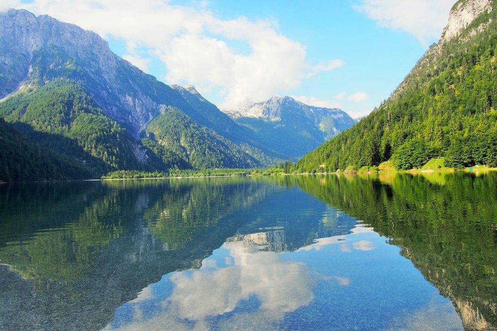
Lake Bled to Vintgar Gorge Trail
For a more relaxed yet equally stunning hike, the Lake Bled to Vintgar Gorge Trail is a perfect choice. This trail takes you through one of Slovenia’s most picturesque landscapes, and it offers views of the iconic Lake Bled and its famous island.
The hike is easy-to-moderate, and it’s ideal for those of you who want to experience Slovenia’s natural beauty without tackling a mountain summit. Along the way, you’ll get to explore some lush forests and the mesmerizing Vintgar Gorge.
Trail Snapshot
Difficulty: Easy–Moderate
Distance: 8 km round trip
Elevation Gain: ~150 m
Start / End: Lake Bled → Vintgar Gorge
Highlights: turquoise lake views, river gorge, forest trails
Difficulty/Recommended Fitness Level
This trail is easy-to-moderate overall, which makes it suitable for hikers of all levels.
The path is mostly well-maintained, with some slight inclines and smooth trails so it’s perfect for families or those new to hiking.
It’s a great option for anyone looking for a leisurely but scenic hike.
Distance
The Lake Bled to Vintgar Gorge Trail is approximately 4 kilometers (2.5 miles) one way. The round trip is about 8 kilometers (5 miles), and you can expect to complete it in about 2.5 to 3 hours overall.
Elevation Gain
The elevation gain on this hike is relatively modest, at around 150 meters (492 feet). The ascent is gentle, which makes it a comfortable and easy hike for most people, even if you’re not a regular hiker.
Start and End Point
The hike begins at Lake Bled, one of Slovenia’s most famous landmarks, where you can admire the lake’s turquoise waters and the island in the middle.
From there, you can follow the trail that leads you through the lush woods and eventually reaches the spectacular Vintgar Gorge. You’ll return the same way or take a bus from the gorge to get back to Lake Bled.
Get to the Trailhead
Lake Bled is easily accessible from Ljubljana by car or bus.
Highlights & Landmarks
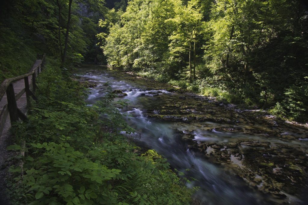
The highlight of this hike is Vintgar Gorge, which is a 1.6-kilometer (1-mile) long gorge carved by the Radovna River, with wooden walkways that take you right above the river.
It offers jaw-dropping views of waterfalls, rapids, and crystal-clear pools. Along the way, you’ll also get a chance to see the Church of St. Catherine, which sits on the shores of Lake Bled and adds a touch of history to your hike.

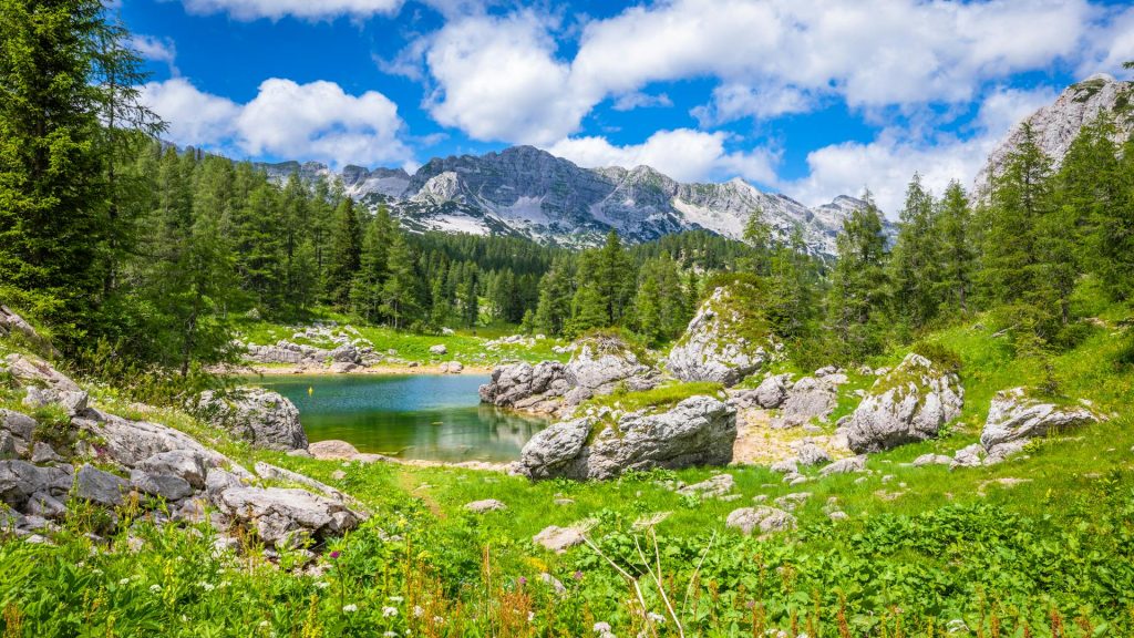
Pokljuka Plateau to the Triglav Lakes
For those who want to explore Slovenia’s alpine beauty without the intense challenge of summiting Triglav, the Pokljuka Plateau to Triglav Lakes Trail is a fantastic option.
This hike takes you through the lush forests of the Triglav National Park and past scenic alpine meadows.
It’s an ideal hike for those who want to experience the beauty of Slovenia’s highlands at a more relaxed pace while still being immersed in stunning scenery.
Trail Snapshot
Difficulty: Moderate
Distance: 12 km round trip
Elevation Gain: ~800 m
Start / End: Pokljuka Plateau
Highlights: alpine meadows, glacial lakes, Julian Alps scenery
Difficulty/Recommended Fitness Level
This hike is moderate, so it’s suitable for hikers with a good fitness level but not necessarily for those looking for a strenuous climb.
The trail involves some elevation gain, and especially as you approach the lakes, but it’s manageable for most hikers who enjoy a moderate challenge.
Distance
The trail is around 12 kilometers (7.5 miles) round trip. Depending on your pace and how long you stop to enjoy the views, you can expect to spend about 5 to 6 hours completing the hike.
Elevation Gain
The elevation gain on this hike is about 800 meters (2,625 feet). The climb is steady but not overwhelming, and it offers a good workout without feeling overly strenuous. The views become more breathtaking as you gain elevation.
Start and End Point
The hike begins at the Pokljuka Plateau, and it’s accessible from the road leading to the mountain pass.
From there, you can follow the well-marked trail that leads you through the forest and into the Triglav Lakes Valley.
The trail loops around the lakes, and it offers some nice and stunning views before heading back the way you came.
Get to the Trailhead
Pokljuka is reachable by car from Bled.
Highlights & Landmarks
The Triglav Lakes are a true highlight of this trail. These glacial lakes are surrounded by dramatic peaks and offer some of the most picturesque alpine scenery in Slovenia.
The area is also rich in history, as it was once an important area for the local shepherds.
Along the hike, you may also come across old shepherds’ huts, which adds a touch of tradition to the experience and will help you to see the rugged side of Slovenia.
Karavanke Ridge Trail
If you’re looking for a challenge with rewarding views of both Slovenia and Austria, the Karavanke Ridge Trail is an unforgettable adventure.
This ridge hike takes you along the border between Slovenia and Austria, and it offers sweeping views of the Alps and charming villages below.
It’s perfect for those who enjoy a more rugged and exposed trail, with a little bit of scrambling and alpine atmosphere along the way.
Trail Snapshot
Difficulty: Challenging
Distance: 20 km one way
Elevation Gain: ~1,500 m
Start / End: Jesenice → Hochstuhl summit
Highlights: Alpine ridge walking, Slovenia–Austria border views
Difficulty/Recommended Fitness Level
This hike is considered challenging, so it’s best for experienced hikers with a good fitness level.
The terrain can be rocky, and there are some sections that require scrambling or using hands for support, and particularly near the summit.
It’s an exhilarating trail that will require stamina (and a bit of inner confidence) on your part, so be ready for it!
Distance
The Karavanke Ridge Trail spans about 20 kilometers (12.4 miles) one way, which really makes it a long and demanding hike. You can expect to spend around 8 to 10 hours on the trail, depending on your pacing.
Elevation Gain
The elevation gain on this trail is roughly 1,500 meters (4,920 feet), which makes for a significant climb.
The trail gradually ascends, and it offers plenty of opportunities for breaks, but you’ll need to be prepared for the physical challenge of a long and steep ascent.
Start and End Point
The trail begins at the town of Jesenice in Slovenia, and the route follows the ridge line all the way along the border with Austria, before eventually reaching the summit of the highest point, the 2,240-meter (7,350-foot) Hochstuhl. You can either turn back at the summit or descend into the Austrian side.
Get to the Trailhead
Jesenice is accessible by train or car from Ljubljana.
Highlights & Landmarks
The Karavanke Ridge is rich in both natural beauty and history. As you hike, you’ll have views of the rugged Alpine peaks and peaceful valleys that stretch across two countries.
The ridge has strategic historical significance, as it once marked a border during the Austro-Hungarian Empire and played a role in past military operations.
Along the way, you’ll pass remnants of old fortifications, adding a cultural layer to the hike. The combination of natural beauty, challenging terrain, and historical significance makes this trail one of Slovenia’s most rewarding hikes for those who love adventure.
The Soča River Trail
For a hike that combines spectacular views and a touch of history, the Soča River Trail is a must. This trail follows the stunning Soča River through the emerald-green valleys of Slovenia’s western Alps.
Known for its striking color, the Soča River offers some of the most beautiful landscapes in the country.
Trail Snapshot
Difficulty: Easy–Moderate
Distance: 23 km total
Elevation Gain: ~200 m
Start / End: Tolmin → Kobarid
Highlights: turquoise river views, waterfalls, WWI history
Difficulty/Recommended Fitness Level
This trail is easy to moderate, making it accessible to hikers of most fitness levels. The path is well-maintained, and the terrain is mostly flat with some gentle inclines.
Distance
The Soča River Trail is approximately 23 kilometers (14.3 miles) in total, but you can hike shorter sections if you prefer. The full trail can take 5 to 7 hours to complete.
Elevation Gain
The elevation gain on the Soča River Trail is minimal, around 200 meters (656 feet). Most of the trail is along the river, so the path is mostly flat with only a few gentle uphill sections.
Start and End Point
The trail starts in the town of Tolmin, which is located in the valley of the Soča River and follows the river through the Triglav National Park. You can choose to hike a specific section of the trail, or complete it all the way to the village of Kobarid.
Get to the Trailhead
Both towns are accessible by bus or car from Ljubljana.
Highlights & Landmarks
The Soča River is famous for its vibrant turquoise color, which comes from the glacial meltwater, and the river valley is surrounded by dramatic mountain scenery too.
Along the way, you’ll pass historical sites related to World War I, as the area was a battlefield during the war.
The Kobarid Museum is a great stop to learn more about the region’s history, and you can also explore the beautiful Kozjak Waterfall as well.
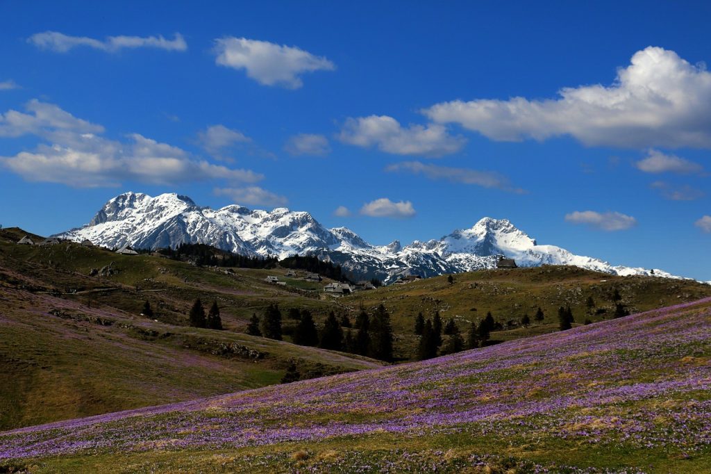
Velika Planina
For a unique and scenic experience, the Velika Planina hike takes you through one of Slovenia’s most charming alpine meadows.
This hike offers breathtaking views of the Kamnik Alps and leads you to the high plateau where traditional herders’ huts (known as “koče”) still stand, which creates a blend of natural beauty and cultural heritage.
The peaceful meadows and picturesque surroundings make this hike perfect for those who want to experience Slovenia’s alpine charm but without tackling the more strenuous climbs like we’ve covered here earlier.
Trail Snapshot
Difficulty: Easy–Moderate
Distance: 6 km round trip
Elevation Gain: ~600 m
Start / End: Kamnik Valley → Velika Planina
Highlights: alpine meadows, traditional shepherd huts, Kamnik Alps views
Difficulty/Recommended Fitness Level
The Velika Planina Trail is easy-to-moderate. The path is mostly gentle with some mild ascents, and there are several options to shorten or extend the trail based on your fitness level.
If you’re looking for a relaxing hike with amazing views, this one’s for you.
Distance
The hike to Velika Planina is about 6 kilometers (3.7 miles) round trip. You can expect to spend around 2 to 3 hours on the trail.
Elevation Gain
The elevation gain is around 600 meters (1,969 feet), which is manageable for most hikers. While the trail does ascend steadily, it’s not overly strenuous.
Start and End Point
The trail starts from the valley near the town of Kamnik, where you can either hike the full way up or take a cable car to the top and then walk through the meadows.
From the summit, the trail follows paths that lead you to Velika Planina, where you’ll find some alpine huts you can stop at. You’ll return the same way.
Get to the Trailhead
Kamnik lies about 30 minutes from Ljubljana.
Highlights & Landmarks
Velika Planina is not only a stunning natural location but also a cultural treasure.
The area is famous for its traditional herders’ settlements, where you can see the unique wooden huts that have been used by shepherds for centuries.
These huts, some of which are still in use today, give the area an authentic and historic feel.
Essential Items for Hiking in Slovenia
Footwear
Good footwear is essential, and especially if you plan to tackle the mountainous terrain.
A sturdy pair of hiking boots with solid ankle support and a good grip is a must for most of Slovenia’s more challenging hikes, like those in Triglav National Park.
For easier, more leisurely trails or lakeside walks, trail runners or hiking shoes with good traction will do just fine.
Clothing
The weather in Slovenia can change quickly, and this is especially true up in the mountains, so it’s smart to layer up. You can start with moisture-wicking base layers to keep sweat away, followed by a breathable shirt and hiking pants.
If you’re heading into higher altitudes or planning a long hike, make sure to bring a waterproof jacket and a fleece or down jacket to stay warm if temperatures drop. A hat, sunglasses, and sunscreen are also must-haves for sunny days.
Backpack Essentials
A small to medium-sized daypack is perfect for most Slovenian hikes. Pack at least 1 to 1.5 liters of water, some snacks for energy, and a basic first-aid kit.
It’s also smart to carry a map or a GPS device, especially if you’re venturing into less-marked trails. Cell service can be spotty in some remote areas, so offline maps can come in handy.
Other Essentials
Sun protection is key, particularly if you’re hiking in the summer, so don’t forget your sunscreen, sunglasses, and a hat to protect yourself from the strong mountain sun.
Insect repellent is a good idea for forested or lakeside hikes, and a lightweight headlamp or flashlight is useful if you’re planning to start your hike early or end it later in the day. With the right gear, you’ll be ready to take on Slovenia’s trails!
🗒️ Free Checklist: “Never forget the essentials — grab your free Ultimate Hiking Packing List.”
Walking Holidays in Slovenia
Slovenia is one of the best destinations in Europe for walking holidays . The country’s compact size allows travelers to explore multiple regions within a single trip.
Many visitors base themselves in towns like Bled, Bohinj, or Kranjska Gora while exploring nearby trails in the Julian Alps.
Hut-to-hut hiking routes in Triglav National Park allow hikers to experience the mountains over several days.
With its combination of alpine landscapes, cultural villages, and excellent trail infrastructure, Slovenia offers a perfect balance between adventure and accessibility.
“Plan less, walk more.” Pick a route, set your pace, and let Europe unfold under your boots: grab your free Walking Holiday ebook today”
Conclusion
From the iconic heights of Triglav to the peaceful serenity of the Soča River, these trails showcase Slovenia’s truly diverse landscapes in the best possible way.
It doesn’t really matter whether you’re a seasoned hiker or just looking to explore, because Slovenia’s got a good trail waiting for you to discover.
Where to Next?
If Slovenia’s alpine trails have sparked your interest in exploring Central Europe on foot, these destinations offer more scenic routes, historic walking cities, and unforgettable mountain adventures.
Nearby Hiking Destinations
Best Hikes in Austria (dramatic Alpine ridges, glacier valleys, and classic Tyrol mountain trails)
Best Hikes in Italy (Dolomite peaks, alpine lakes, and spectacular mountain villages)
Ultimate Guide to Hiking in Croatia (coastal trails, national parks, and island hiking routes along the Adriatic)
Ljubljana: A City Guide for Hikers (castle viewpoints, riverside paths, and historic bridges in Slovenia’s charming capital)
Wider European Hiking Inspiration
Best Hikes in Switzerland (legendary Alpine routes, glacier valleys, and dramatic mountain passes)
Best Hikes in France (Alpine treks, Pyrenees routes, and scenic countryside trails)
Tour du Mont Blanc (one of Europe’s most famous long-distance treks across France, Italy, and Switzerland)
West Highland Way (Scotland) (a classic long-distance trail through the Scottish Highlands)


