
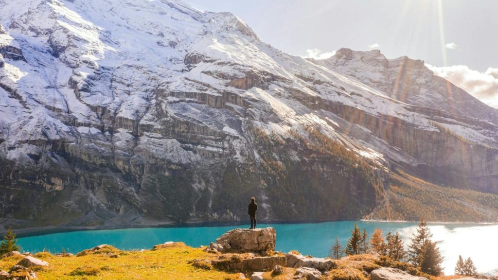
Based on images and movies you’ve seen, you may think that every hiking trail in Switzerland leads to breathtaking views of snow-capped peaks, emerald lakes, and charming alpine villages…and that’s really not too far off from reality!
This small, landlocked country nestled right in the middle of the Alps really does provide some of the very best hiking experiences in Europe (and the world, for that matter).
From the iconic trails of the Swiss Alps to hidden gems like we’ll explore below that will showcase to you the country’s rich cultural heritage, there’s a perfect hike for beginners and experts alike in Switzerland.
Why Hike in Switzerland?
Based on the photos and films you’ve probably seen, it’s easy to assume that every trail in Switzerland leads to snow-capped peaks, emerald lakes, and storybook alpine villages—and honestly, that impression isn’t far off.
Despite its small size, Switzerland sits right at the heart of the Alps and delivers some of the most consistently rewarding hiking in Europe. Well-maintained paths, clear signage, and reliable transport make it easy to explore, while the scenery rarely lets up.
What truly sets Switzerland apart is variety. In a single trip, you can hike beneath iconic faces like the Eiger, wander past reflective mountain lakes near Zermatt, traverse dramatic ridgelines above turquoise valleys, and descend into waterfall-filled basins like Lauterbrunnen.
Add in a strong mountain culture, historic routes, and trails suited to both beginners and seasoned hikers, and Switzerland becomes a place you’ll want to return to again and again.
Companion Article: Ultimate Guide to Hiking in Switzerland
Looking for the bigger picture? Our in-depth guide covers regions, seasons, trail grading, and what to expect at altitude—plus practical tips for transport, huts, and weather planning.
Check out our Ultimate Guide to Hiking in Switzerland for planning, regions, and trail tips.
The Best Hikes in Switzerland
From legendary north faces to lake-dotted plateaus and exposed ridges, these trails showcase Switzerland’s range. Pick a classic for first-time wow factor, or push yourself on a dramatic high route if you’re after a true Alpine challenge.
1. The Eiger Trail
The Eiger Trail is renowned for its close proximity to the north face of the Eiger, which is one of the most legendary and challenging climbs in the world. As you hike, you’ll be treated to dramatic views of this towering peak.
Its sheer rock face rises by nearly 1,800 meters/5,900 feet above you. This would be one of your best hiking in Switzerland.
Trail Snapshot
Difficulty: Moderate
Distance: 6.4 km / 4 mi
Elevation Gain: ~800 m / 2,625 ft
Start / End: Eigergletscher → Alpiglen
Highlights: Eiger north face, alpine history, dramatic rock walls
Difficulty/Recommended Fitness Level
The Eiger Trail is a moderately challenging hike. It is best suited for hikers with a good level of fitness, and it’s perfect for those seeking a close-up view of the Eiger.
Distance
The trail is approximately 4 miles/6.4 km long, which makes it an ideal day hike that typically takes up to 3 hours to complete.
Elevation Gain
The hike involves an elevation gain of about 800 meters/2,625 feet. The trail is mostly downhill from the starting point, but there are some steep and rocky sections that will really require you to watch your step!
Start and End Point
The hike begins at the Eigergletscher station, which is accessible by train from Grindelwald or Wengen. The trail winds down to Alpiglen, which is a small hamlet where you can catch a train back to your starting point or continue exploring the region if you wish.
Unique/Interesting Points/Cultural or Historical Points of Note
This trail is absolutely steeped in mountaineering history, as the Eiger’s north face, known as the “Nordwand,” has been a coveted and dangerous climb for alpinists since the 1930s.
Along the trail, you’ll sefe memorials to climbers who have attempted the ascent, as well as information boards that tell the story of the Eiger’s formidable reputation.

2. The Five Lakes Walk (5-Seenweg)
The Five Lakes Walk is famous for its stunning views of the Matterhorn, one of Switzerland’s most iconic peaks. The trail takes you past five beautiful alpine lakes (namely, the Stellisee, Grindjisee, Grünsee, Moosjisee, and Leisee).
Each lake offers its own unique perspective of the Matterhorn, and some even provide perfect reflections of the mountain in their crystal-clear waters (bring your camera!).
Trail Snapshot
Difficulty: Easy to Moderate
Distance: 10 km / 6 mi
Elevation Gain: ~300 m / 985 ft
Start / End: Blauherd loop
Highlights: Matterhorn views, alpine lakes, reflections
Difficulty/Recommended Fitness Level
The Five Lakes Walk is a moderately easy hike and is suitable for hikers of all fitness levels. It’s one of the best hikes in the country for families and beginners for this reason, and the views are truly rewarding.
Distance
The trail is approximately 6 miles/10 km long, making it a perfect half-day hike that typically takes around 3 to 4 hours to complete.
Elevation Gain
The hike involves a gentle elevation gain of about 300 meters/985 feet. The trail is well-marked and maintained, with a few short uphill sections, but overall it’s a relatively easy trek.
Start and End Point
The hike starts and ends at the Blauherd station, which is accessible by a funicular from Zermatt. This is a loop trail, so you’ll return to your starting point.
Get to the Trailhead
Take the funicular and gondola from Zermatt up to Blauherd—no car needed.
Highlights & Landmarks
Stellisee’s classic Matterhorn reflection steals the show, while quieter lakes like Grindjisee and Grünsee offer different angles and moods.

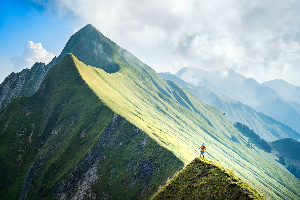
3. The Hardergrat Trail
The Hardergrat Trail is renowned for its exhilarating views but also its challenging terrain, and is often (appropriately) described as one of the most beautiful and terrifying hikes in the world.
Trail Snapshot
Difficulty: Very Challenging
Distance: 24 km / 15 mi
Elevation Gain: ~1,500 m / 4,920 ft
Start / End: Harder Kulm → Brienzer Rothorn
Highlights: Knife-edge ridge, Lake Brienz views
Difficulty/Recommended Fitness Level
The Hardergrat Trail is a strenuous and challenging hike. It’s good only for experienced hikers with a high level of fitness and a head for the heights! That being said, it’s also one of the best hikes in Switzerland for thrill-seekers who want to test their limits on one of the most dramatic ridgelines in the Alps.
Distance
The trail spans approximately 15 miles/24 km, making it a full-day hike that typically takes up to 8 hours to complete.
Elevation Gain
This hike involves significant elevation gain, with around 1,500 meters/4,920 feet of ascent and descent.
The trail follows a narrow ridge with steep drop-offs on both sides, and it will really require sure-footedness and strong stamina on your part if you want to hike the whole thing safely.
Start and End Point
The hike begins at the Harder Kulm, which is accessible by a funicular from Interlaken. The trail follows the ridge all the way to Brienzer Rothorn, where you can take a cogwheel train down to Brienz or retrace your steps if you prefer.
Get to the Trailhead
Ride the funicular from Interlaken to Harder Kulm. Finish by taking the cogwheel train down from Brienzer Rothorn to Brienz.
Highlights & Landmarks
Unbroken views over turquoise Lake Brienz contrast with sheer drops on both sides of the ridge—thrilling and intimidating in equal measure.
4. The Aletsch Glacier Panorama Trail
The Aletsch Glacier Panorama Trail offers some of the most breathtaking views of the Aletsch Glacier, which is the largest glacier in the entire Alps mountain range. Stretching over 23 kilometers/14 miles, this glacier is a UNESCO World Heritage site and a true natural wonder.
Trail Snapshot
Difficulty: Moderate
Distance: 11 km / 7 mi
Elevation Gain: ~500 m / 1,640 ft
Start / End: Bettmerhorn → Riederalp
Highlights: Aletsch Glacier, UNESCO landscape
Difficulty/Recommended Fitness Level
The Aletsch Glacier Panorama Trail is a moderately challenging hike, suitable for hikers with a moderate fitness level. It’s ideal for those of you who would like to experience the majesty of the Alps without overly strenuous climbs. It’s undoubtedly one of the very best hikes in all of Europe for stunning glacier views.
Distance
The trail is approximately 7 miles/11 km long. It will make for a comfortable hike that takes up a majority, but not all, of your day.
Elevation Gain
The hike involves a moderate elevation gain of about 500 meters/1,640 feet. The trail is well-marked and maintained, with some gentle ups and downs along the route.
Start and End Point
The hike begins at the Bettmerhorn cable car station, accessible from Bettmeralp, and ends at the Riederalp cable car station.
Get to the Trailhead
Take the cable car from Bettmeralp up to Bettmerhorn. At the end, descend by cable car from Riederalp to the valley.
Highlights & Landmarks
Views of the UNESCO-listed Aletsch Glacier dominate, with Marjelensee adding a reflective foreground in summer.
5. The Via Alpina (Grindelwald to Lauterbrunnen)
The Via Alpina from Grindelwald to Lauterbrunnen offers some of the most iconic views in the Swiss Alps, including breathtaking panoramas of the Eiger, Mönch, and Jungfrau mountains all on the same trail! In the process, as you hike you’ll pass through lush meadows, dense forests, and dramatic cliffside paths.
Trail Snapshot
Difficulty: Moderate
Distance: 16 km / 10 mi
Elevation Gain: ~900 m / 2,950 ft
Start / End: Grindelwald → Lauterbrunnen
Highlights: Jungfrau region, waterfalls, alpine meadows
Difficulty/Recommended Fitness Level
The section of the Via Alpina from Grindelwald to Lauterbrunnen is a moderately difficult hike, and is a good pick for hikers with a moderate level of fitness. Beginner hikers may want to think twice.
Distance
This section of the Via Alpina is approximately 10 miles/16 km long. It’s a full day hike for most people.
Elevation Gain
The hike involves an elevation gain of about 900 meters/2,950 feet, with both ascents and descents as you traverse high alpine terrain. The trail includes some steep sections but these are all well-marked and maintained for safety purposes.
Start and End Point
The hike starts in the picturesque village of Grindelwald and ends in Lauterbrunnen, often referred to as the “Valley of 72 Waterfalls.” Both towns are well-connected by trains and buses.
Get to the Trailhead
Both villages are well connected by train. Travel light and enjoy an easy return by rail at the end.
Highlights & Landmarks
The descent into Lauterbrunnen reveals cliffs streaked with waterfalls, including the iconic Staubbach Falls.

6. The Zermatt to Schonbielhutte Hike
The Zermatt to Schonbielhutte hike offers some of the most spectacular views of the Matterhorn, which is one of the most iconic and well-known peaks in the entire world. Specifically, the Schonbielhutte provides a perfect vantage point to take in these views, with the Matterhorn looming majestically over the whole of the valley.
Trail Snapshot
Difficulty: Moderate
Distance: 14.5 km / 9 mi (round trip)
Elevation Gain: ~800 m / 2,625 ft
Start / End: Zermatt → Schönbielhütte
Highlights: Matterhorn views, historic mountain hut
Difficulty/Recommended Fitness Level
This is a moderately challenging trek, and is suitable for hikers with a decent level of fitness. It’s ideal for those who want to experience the grandeur of the Matterhorn and the surrounding alpine scenery while tackling somewhat but not extremely difficult terrain.
Distance
The hike covers approximately 9 miles/14.5 km round-trip. It could take up to a full day to complete.
Elevation Gain
This hike involves an elevation gain of about 800 meters/2,625 feet. The trail ascends steadily from Zermatt, with some steeper sections as you approach the Schonbielhutte. It should remain manageable for most hikers.
Start and End Point
The hike begins in the town of Zermatt, which is famous in Switzerland for its car-free streets that create a more ‘homely’ feel. The trail leads to the Schonbielhutte, a mountain hut located on the western side of the Matterhorn, and then returns to Zermatt by the same route.
Get to the Trailhead
Begin directly from Zermatt’s car-free center; clear signage leads onto the trail.
Highlights & Landmarks
Schönbielhütte, built in 1909, offers a front-row seat to the Matterhorn and a tangible link to Alpine climbing history.

What to Bring for Hiking in Switzerland
- Good Footwear
- A good pair of hiking boots is crucial to hike Switzerland’s trails, which can range from well-maintained paths to rocky, uneven terrain (especially in the higher altitudes of the Alps). Boots with good ankle support and a sturdy grip will keep you stable and comfortable on the trail. If you do have foot issues, don’t miss out on reading our How to Treat Sore Feet After Hiking guide.
- Backpack
- A reliable daypack is important even if you’re just headed out for part of a day or just an hour or two. Make sure it’s large enough to carry water, snacks, a first aid kit, and extra layers.
🗒️ Free Checklist: “Pack light, pack right — download The Ultimate Hiking Packing List.”
- Clothing
- Layering is also important when hiking in Switzerland, and especially in the colder months. Start with a moisture-wicking base layer to keep sweat off your skin, add an insulating mid-layer for warmth, and then have a waterproof and windproof outer layer that covers everything. Even on a sunny day, weather in the mountains can change quickly, so be prepared for rain, wind, or sudden temperature drops.
- More Important Items
- Additional items you’ll want to bring as well when you hike in Switzerland include a map or GPS device to navigate the trails, a hat and sunglasses for sun protection, and sunscreen. Trekking poles can be particularly helpful on steep or uneven terrain, and a reusable water bottle or hydration system of some kind is an absolute must in order to remain hydrated.
Walking Holidays in Switzerland
Switzerland is tailor-made for walking holidays. Efficient public transport makes point-to-point routes painless, while mountain huts and village inns provide welcoming stops along the way.
You can string together classics like sections of the Via Alpina, linger above glaciers on the Aletsch Panorama Trail, or base yourself in places like Zermatt or Grindelwald and explore day hikes with luggage-free ease.
The terrain shifts quickly—from lake shores to high passes—keeping multi-day walks varied and engaging. Add in local cheese, chocolate, and postcard villages, and you’ve got a walking holiday that balances effort with comfort.
If multi-day walking sounds like your style, browse our Walking Holidays in Switzerland for more information
“From Alps to coastlines, our free Walking Holiday guide helps you plan smarter.”
Conclusion
Make no mistake about it, Switzerland offers some of the most breathtaking trails in Europe. Each hike in this guide showcases the unique beauty of this wonderful country, whether you’re gazing up at the iconic Matterhorn, trekking alongside the vast Aletsch Glacier, or immersing yourself in the vibrant colors of alpine meadows. Hiking in Switzerland is truly special.
Where to Next?
Here are other hiking destinations you might enjoy after Switzerland:
- Ultimate Guide to Hiking in Italy
- Best Hikes in Austria
- Walking Holidays in France
- Best Hikes in Germany
Wider European inspiration:
- Best Hikes in Croatia
- Via Dinarica (White Trail)
- Hiking the West Highland Way
- Ultimate Guide to Hiking in Portugal


